Devil's Hole Massacre
item
- Title
- Devil's Hole Massacre
- Date
- 1763/08/14 (date of event)
- ca 1975 (reproduction)
- Creator
- Breton, Carol
- Extent
- 36.21 x 25.7 cm
- Is Part Of
- Watercolour Collection
- Description
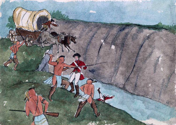
- Devil's Hole Ravine is located along the American shoreline of the Niagara River Gorge just north of the Niagara Glen. It is a deep, bowl shaped basin of the Bloody Run tributary from Glacial Lake Tonawanda ;
- en-CA Niagara Falls Heritage Foundation Government of Canada Local Initiatives Grant AK 2403-9 1974 - 1975 ; research by George Seibel ; When the French occupied the east bank of the Niagara River and operated the Portage they employed Seneca Indians to carry the good on their backs up the steep incline of the escarpment, which became known as "Crawl-on-all-Fours", and along the Portage path to Fort Little Niagara above the Falls. When the British took over after they defeated the French and took control of Fort Niagara in 1759, they changed the methods of carrying goods, supplanting Indian labour with wagons pulled by horses and oxen. This loss of employment and other actions of the British who were more and more encroaching on Indian territory angered the Seneca Indians. On Spetember 14th, 1763, the Indians were driven to drastic measures to make their claims known, they ambushed a wagon train, killing most of the drivers and soldiers who accompanied the train ;
- Type
- Still Image
- Medium
- Watercolour
- Subject
- Military
- Native Peoples
- Location
- United States
- Identifier
- http://www.nflibrary.ca/nfplindex/show.asp?b=1&ref=oo&id=102826
- locator
- WC 27
- Publisher
- Niagara Falls Heritage Foundation
- Date Created
- 2005-02-24
- Date Modified
- 2005-02-24
- Media
 Devils Hole Massacre
- Item sets
- Art database