Browse Items
-
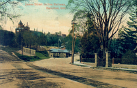
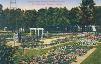 Famous Rose Garden Montebello Park St Catharines Ontario Canada A formal rose garden is situated in the middle of the Montebello park ; an arbour (centre) ; a large metal structure (top left corner) ; 3 people are standing in front of the metal structure ;
 -
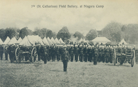 7th (St Catharines) Field Battery at Niagara Camp Soldiers are on parade ; tents in background ; two military wheeled guns are in front of troops ; an officer is at the head of the parade ;
 -
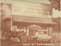 Main Street Effingham A W Moore general store ; single story frame building ; advertising sign above door offers "dealer, drugs, groceries, boots, shoes & dry goods and Effingham PO [Post Office] ; a horse and buggy with people in with a large umbrella in foreground of image ; a man is standing near the store entrance ; a house in background is largely obscured by the advertising sign ;
 -
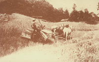 Town of Pelham Beckett Farm in the Short Hills of Effingham Farmer Taylor Beckett is shown operating hay binder pulled by three horses ;
 -
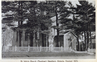 St John's Church (Anglican) Stamford Ontario erected 1825 Single story building with gothic arch windows; steep roof with bell tower ; small enclosed entrance centre ; lattice type fence in front ; mature trees partially obscure the building ;
 -
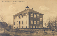 New Union School Stamford and southend Ontario Two story red brick building ; peaked roof with small tower with flag pole ; trees ;
 -
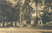 Lodge cottage and entrance to grounds of Sir Peregrine Maitland Governor of Upper Canada built about 1820 Stamford Village Ontario Surrounded by mature trees and a picket fence ; the cottage is partially obscured by the trees
 -
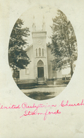 United Presbyterian Church Stamford Front view of the entrance to the church ; surrounded by trees ; a simple post and rail fence is around the church ; steps lead to main door ;road side (right) ;
 -
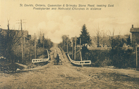 St David's Ontario, Queenston Grimsby Stone Road looking east Presbyterian and Methodist Churches in distance The dirt road is lined with mature trees and hydro/telephone poles a white fence is in the centre of the image built next to a creek ; residential houses are partially hidden by the trees on either side ; tracks can be seen in the dirt road ; a horse and buggy is crossing over the creek bed ;
 -
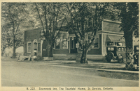 The Shamrock Inn the Tourists' home St David's Ontario Four large mature trees line the sidewalk ; the inn is partially obscured by the trees ; two story frame house with side/front porch ; two cars are parked (centre right) ;
 -
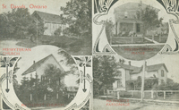 St David's Ontario The card is divided into 4 sections with 4 individual images ; Top Row L-R: Presbyterian Church, Presbyterian Manse ; Bottom Row L-R: Methodist Church, Methodist Parsonage ; text in red ;
 -
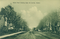 Stone Road (looking east) St David's Ontario The entire dirt road is lined with mature trees ; residential houses are partially hidden by the trees ; tracks can be seen in the dirt road from either a car or a wagon ;
 -
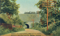 Ravine Hill and tunnel under GTR [Grand Trunk Railroad] tracks between Stamford and St David's Ontario Looking north toward St David's ; the tunnel and bridge made of stone are located at the bottom of Ravine Hill ; a train is crossing on the tracks ;many trees line the dirt road ; wooden hydro poles (right) ; a woman is standing under the trees to the left ;
 -
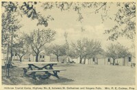 Hillbrow Tourist Camp Highway No 8 between St Catharines and Niagara Falls. Mrs R E Cudney Prop [proprietor] Six small cabins are set amongst flowering trees ; picnic benches in front of some cabins and on the grass ;
 -
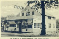 The Old Mill Inn St David's Highway No 8 near Niagara Falls Canada A two story frame house with a large porch addition to the front serving as the entrance to the inn ; picket fence to the right ; a roof top sign advertises "Blacks The Old Mill Inn" ; advertising above the entrance doorway for "English Sausage Rolls" ; sign advertising "Rooms" on the right of the building ;
 -
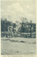 Crusher plant of Queenston Quarries St David's Ontario The crushing plant is located on a hill side ; trees surround it ;
 -
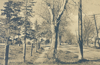 Main Street (looking north) residential section of St David's Ontario Large mature trees line the dirt road that is Main Street ; houses are partially obscured by the trees ; a fence made of simple posts line the roadway ; hydro poles and telephone poles visible right ;
 -
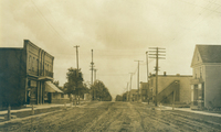
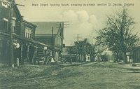 Main Street looking south showing business section St David's Ontario Stores line the dirt road which is Main Street ; a horse and cart is outside a store (left) ; the pole in the foreground (left) of the image reads "Bell Telephone Co. ; trees are on both sides of the street ;
 -
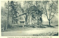 Presbyterian Church St David's Ontario. Headquarters of de Rottenberg 1812 Brick single story building ; six steps lead to main entrance ; church is surrounded by trees and a dirt roadway runs in front ;
 -
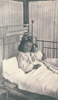 St David's Methodist S S Cot. A small girl dressed in night clothes and clutching a doll is in a hospital bed ; surrounded by screens ;
 -
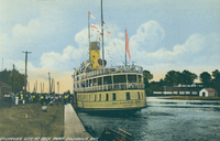
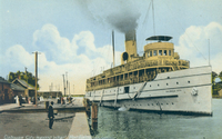 Dalhousie City leaving wharf Port Dalhousie Ont [Ontario] The steam ship Dalhousie City laden with passengers probably returning to Toronto pulling away the dock ; smoke is pouring from the single funnel ; people are on the dock watching the ship pull away ;
 -
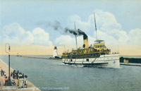 Dalhousie City arriving at Port Dalhousie Ont [Ontario] The steam ship Dalhousie City laden with passengers probably from Toronto pulling into the dock ; other people are waiting on the dock either to meet arrivals or to take the outbound boat ; Port Dalhousie light house centre ;
 -
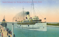 Steamer Dalhousie City arriving at Port Dalhousie Ontario Canada The steam ship Dalhousie City laden with passengers probably from Toronto pulling into the dock ; other passengers are awaiting boarding on the dock; a smaller ship in background left ;
 -
 Dalhousie City at dock Port Dalhousie Ont [Ontario] The steam ship Dalhousie City at the dock ; passengers are awaiting boarding ; Toronto painted on bow of ship ;
 -
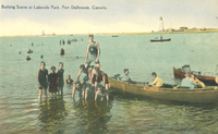 Bathing scene at Lakeside Park Port Dalhousie Canada rowing boats row
 -
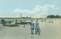 Bathing beach [Lakeside Park] Port Dalhousie Ont [Ontario] rowing boats row
 -
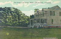
 Roadway to Sugar Loaf Hill Port Colborne Ont [Ontario] A winding dirt road leads uphill toward Sugar Loaf Hill (top right) ; scrub and bushes line the roadway and hydro poles are located at intervals ; heavier tree growth (left) ;
 -
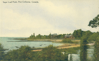 Sugar Loaf Point Port Colborne Canada Situated on the north shore of Lake Erie Sugar Loaf was the original name of the settlement that later became Gravelly and then Port Colborne ; sandy beach lines the shore ; two houses can be seen in background (centre) ; and a dock extends into the Lake (centre) ;
 -
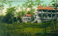 Solid Comfort East End Port Colborne Ont [Ontario] A very large two story house nestled amongst trees ; wrap around verandahs on both levels of the house, central wooden staircase leads to main entrance and a large turret is to the left ; a smaller version of the house is to the extreme left ;
 -
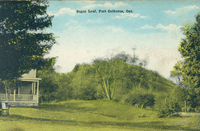 Sugar Loaf Port Colborne Ont [Ontario] Sugar Loaf Hill is in the centre of the image ; the house known as the Sugar Loaf home is partially visible (bottom left), part of the porch and verandah are shown ;
 -
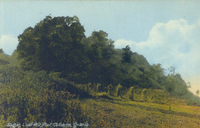 Sugar Loaf Hill Port Colborne Ontario Pastoral scene with trees bushes and grass
 -
 The Sugar Loaf Home Port Colborne Canada A two story home with dormer windows in the roof and a large front verandah and porch ; two people are on the porch and another four possibly children are leaning against the porch ; trees in background and grass in foreground ;
 -
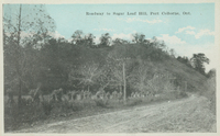
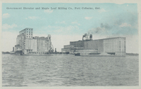
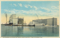
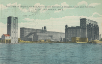 Rear view Maple Leaf Mill, Government Elevator & Niagara Grain & Feed Co [Company] Port Colborne Ont [Ontario] On the north shore of Lake Erie, on the Welland Canal
 -
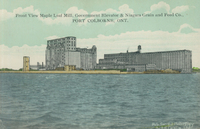 Front view Maple Leaf Mill, Government Elevator & Niagara Grain & Feed Co [Company] Port Colborne Ont [Ontario] On the north shore of Lake Erie, on the Welland Canal
 -
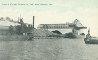
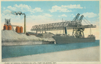 Plant of Canada Furnace Co [Company] Ltd [Limited] Port Colborne Ont [Ontario] Welland Canal in foreground, mounds of coal line the bank of the canal ; a very large steel structure is in centre of image, ; sign for C F Co Ltd attached to top of first steel structure ; a large lake boat (laker) is docked underneath the steel structure ;
 -
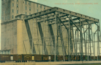 Grain Elevator Port Colborne Ont [Ontario] Massive brick building more than four stories high ; a large steel structure is attached to the near side of the building ; railway box cars from Great North West and South Western Pacific are under the steel structure ;
 -
 Maple Leaf Flour Mill Port Colborne Ontario On the north shore of Lake Erie, a large lake grain boat is docked on the near side of the first building ; smaller buildings line the bank of the canal and larger ones in background ;
 -
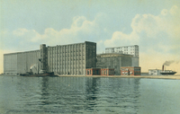
 Government Elevator and Maple Leaf Milling Co [Company] Port Colborne Ont [Ontario] On the north shore of Lake Erie, a large lake grain boat is docked next to the Government Elevator (left) Maple Leaf Mill is right ;
 -
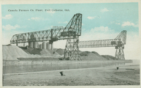 Canada Furnace Co [Company] Plant Port Colborne Ont [Ontario] Welland Canal in foreground, mounds of coal line the bank of the canal ; two very large steel structures in centre of image, small hoppers can be seen within the steel structures ; sign for C F Co Ltd attached to top of first steel structure ;
 -
 Government Elevator and Maple Leaf Flour Mill Port Colborne Ont [Ontario] On the north shore of Lake Erie, a large lake boat is docked next to the Government Elevator (left) Maple Leaf Mill is right ;
 -
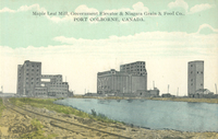 Maple Leaf Mill, Government Elevator & Niagara Grain & Feed Co [Company] Port Colborne Canada On the north shore of Lake Erie, from L-R Maple leaf Mills, Government Elevator, Niagara Grain & Feed, canal running through centre of image and railway tracks to the left ;
 -
 Plant of Canada Furnace Co [Company] Ltd [Limited] Port Colborne Ont [Ontario] On the north shore of Lake Erie which is visible in the foreground, smoke stacks and mounds of coal ; a lake boat in distance (far right) and a tug boat is (centre right)
 -
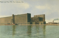 Maple Leaf Flour Mill Port Colborne Ont [Ontario] Factory buildings located at edge of the north shore of Lake Erie ; grain elevator visible in front building and a grain lake boat or freighter is discharging its load ; any lake boat is in the background (right) ;
 -
 Plant of International Nickel Co [INCO] Port Colborne Ont [Ontario] Distance view of the factory buildings and smoke stacks ; grass and trees surround the plant
 -
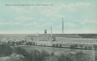
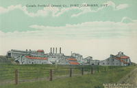 Canada Portland Cement Co [Company] Port Colborne Ont [Ontario] Long view of the factory surrounded by grass
 -
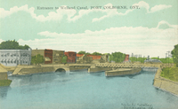 Entrance to Welland Canal Port Colborne Ont [Ontario] The third Welland Canal as it passes through the centre of Port Colborne, stores and businesses (left) ; canal bank and hydro poles (right) ; lock bridge (centre)
 -
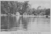 Cottages and bathing beach Sunset Park near North Bay Five small cottages are shown on the edge of a lake ; large trees surround the cottages ; canoes are beached in front of two of the cottages ;
 -
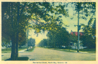 Residential street North Bay Ontario Shows tree lined street with houses obscured by trees ; hydro poles (left and right)
 -
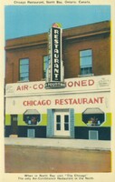 When in North Bay visit "The Chicago" the only air-conditioned restaurant in the North A red brick building with an art deco entrance to the restaurant, port hole windows ; a large sign running the lengthwise down the building advertises restaurant and soda fountain ; a horizontal sign above the entrance advertises the air-conditioning as being by H H Lock and Sons Toronto ;
 -
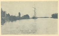 The Erie Belle Chippawa 1911 In background left is shown the original mouth of the Welland River where it joins the Niagara about one mile above the famous cataract ; to the right are shown the man-made Hog Island and channel dug in 1827 ; the smoke stack in the background is from a factory on the American side of the Niagara River
 -
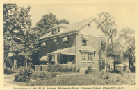 Tourist Home Of Mrs M W Schrader Bridgewater Street Chippawa Ontario Phone 3519 Ring 22 A two story brick home surrounded by trees and garden ; a dormer window set into the roof line and awnings on each of the windows ;
 -
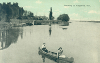
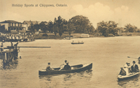 Holiday Sports At Chippawa Ontario Motor boats and row boats in the Chippawa Creek ; people in the boats very formally dressed ; houses along the creek bank in the background ;
 -
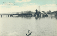
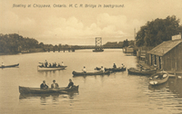 Boating at Chippawa Ontario Five canoes are shown boating in Chippawa Creek, The MCR [Michigan Central Railway bridge is in the background ; Left front canoe inlcudes: Thomas Greenwood, Louise Ackerman, Mrs. Greenwood; Left Upper Canoe: Thomas Downey & unknown; Upper right canoes': Hardy Gerber & Deak Greenwood ; tw small motor boats are shown tied up at the boat house centre right ;
 -
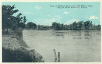 View of Welland River from Old Manor Camp Niagara River Boulevard Canada Welland River seen from the old Macklem House
 -
 Trinity Church Chippawa Ont [Ontario] Ivy covered one story stone building with central spire and bell tower surrounded by trees
 -
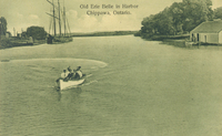 Old Erie Belle in harbor Chippawa Ontario The schooner Erie Belle is docked in Chippawa Harbor (background left) ; a small boat house is (right) ; the small motor boat in the foreground was built in Port Burwell & registered in 1873 ; the Scott family of Buffalo are in the motor boat
 -
 Canoeing at Chippawa Ont [Ontario] Two women identified as Helen Rapeljie in the stern and Eleanor Bukator in the bow paddling in Chippawa ; electric railway poles in background ; verification of identity provided by Eleanor Bukator February 9 1975 ; in background can be seen the old mouth of Chippawa Creek which has now (2008) been filled in and is known as King's Bridge Park ;
 -
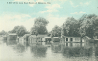 A few of the many boat houses at Chippawa Ont [Ontario]creek Small boat houses along the banks of Chippawa Creek ; boat house extreme left belonged to Walt Gorings, extreme right belonged to Gilbert McMicking then Herman McKenzie ; the largest boat house one in from the right was the club house ;
 -
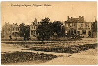 Cummington Square Chippawa Ontario Shops stores and business in downtown Chippawa ; Village of Chippawa Town Hall (centre left) ; Royal Bank of Canada (right) ; horse and buggy is outside the bank ; two men are posing in the centre of the image where the bandshell was later built ;
 -
 Frenchman's Creek Bridge Bridgeburg Ont [Ontario] Small narrow stone bridge ; various men and children are posing on the bridge itself and women and children are seated near the creek bank by one of the bridge supports ;
 -
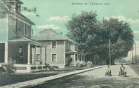 Macklem St [Street] Chippewa sic [Chippawa] Ont [Ontario] View of residential houses on Macklem Street ; two small boys are in foreground playing with home made carts or tricycles ; trolley poles at right ;
 -
 Old Manor Camp Niagara River Boulevard Canada A large stone house ; central steps leading up to main porch with four large pillars an automobile is parked on the driveway ; side porch and verandah to the left ; out buildings to the right ; a large road side advertising sign (bottom right) reads " Old Manor Camp Tourists STOP 150 years old visitors welcome" another sign to the right of the road side sign advertises "Old Manor Restaurant" ; the Niagara River Boulevard/Parkway runs across the bottom of the photograph ;
 -
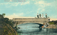
 Bathing at Chippawa M C Ry [Michigan Central Railway] Bridge in background Two men holding onto an overturned canoe in Chippawa Creek (foreground) ; boat houses (right ); Michigan Central Railway [MCR] Bridge in background
 -
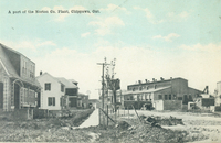 A part of the Norton Co [Company] Plant Chippawa Ont [Ontario] Rows of small residential cottages built for workers at the Norton plant ; dirt road is now the Chippawa Parkway ; newly planted maple trees ;
 -
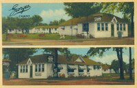 Georges Cabins Main Street East Chippawa Two panoramic views on one card ; view 1 - top small white cabins clustered around grass and flowerbeds ; view 2 - lower - main entrance tor registration, advertising for coffee shop sign on tree in front of buildings ;
 -
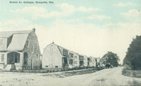 Norton Co Cottages Chippawa Ont [Ontario] A row of small cottages built for workers of the Norton Company in Chippawa, sometimes called Norton Village; note the newly planted maples; Dirt road is now the Chippawa Parkway
 -
 James Street Incline Railway Hamilton Ont [Ontario] View looking south up the escarpment to the Mountain View Hotel at the top of the James Street Incline (Hamilton and Barton Incline Railway) ; (right) entrance gateway to “Ballinahinch”, the mansion built in 1849 for A.S. Kennedy, a prosperous Hamilton dry goods merchant ;
 -
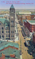 James Street looking north from Bank of Commerce building Hamilton Ont [Ontario] Large grey stone building with clock tower left (possibly old City Hall) ; streetcar bottom right ;
 -
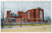 Scottish Rite Cathedral and Club Hamilton Ont [Ontario Canada Red brick building with turrets and large windows behind a wrought iron black fence ; small bare trees line the sidewalk ;
 -
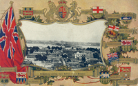 Bridgeburg looking east Buffalo in the distance View of Fort Erie and Bridge in distance ; view is bordered by crests of the Canadian provinces, Newfoundland and Labrador is not included so date must be prior to 1949 ; central crest reada "Honi soit qui mal y pense" translated "Evil be to him who evil thinks"
 -
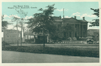
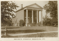 Historical residence Bridgeburg Ont [Ontario] Bertie Hall in Fort Erie ; two story residence with outside porch with four large columns ; water hydrant in foreground ;
 -
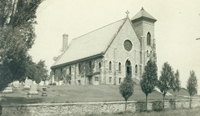
 Central United Church Fort Erie Ontario Large brick building with narrow frontage surrounded by trees ; stone steps lead to main entrance in central tower ;
 -
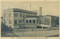 Customs House from Peace Bridge Fort Erie Canada Stone building with ramp leading to entrance surrounded by chain link fence ; flag pole and antennae on roof ;
 -
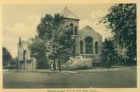
 St. Paul's Anglican Church, Niagara Boulevard - Fort Erie Large brick building with highly sloped roof, incorporates standing tower with gothic arch window to the right ; steep steps lead from the waklway to the church entrance ; gravestones in the surrounding cemetery and four small trees in front of a stone wall in the foreground ;
 -
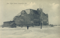 New high school Dunnville Ont [Ontario] The large brick two story school building has a large area of open land around it ; the main entrance has a small tower which holds the flag pole ; as a small shed is to the left and snow is on the ground ; a single male dressed in winter clothing is in the centre of the photograph ;
 -
 Jarvis Street Bridgeburg Ont [Ontario] Jarvis Street at this time is a dirt road, there are stores on the left and also the right ; in the distance on the left and right can be seen residential houses ; hydro poles are located on both sides of the street ;
 -
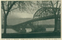 Peace Bridge at twilight linking Canada and the United States at Fort Erie Ont [Ontario] and Buffalo NY [New York] Reverse reads Commemorates 100 years of peace between United States and Canada. Cost $4,500,000. Length 4,900 feet. Dedicated by Prince of Wales and Vice-President Dawes on August 7 1927. Accommodates 3000 autos an hour ;
 -
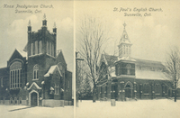 Knox Presbyterian Church Dunnville Ont. St Paul's English Church Dunnville Ont [Ontario] Knox Presbyterian a multi gabled brick building with central bell tower, snow on ground ; St Paul's a brick building with the main entrance offset to the left directly underneath a large bell tower, snow on the ground ;
 -
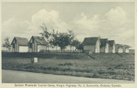 Section Riverside Tourist Camp King's Highway No 3 Dunnville Ontario Canada Seven very small cabins nestled among the trees and grass
 -
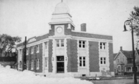 Post Office Dunnville Ontario Post office building with clock tower , flag on clock tower ; clock set to 11:45 am and sign on left side of building reads "Dominion Public Building" sign above entrance "Dunnville", sign above door "Post Office" ; residential houses behind the building to the right ; what looks like snow in the bottom left quadrant is in fact damage to the photograph ;
 -
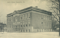 Public school Dunnville Ontario Brick building with flat roof and central portico ; snow on ground ;
 -
 St Paul's Anglican Church Dunnville Ontario Brick building with bell tower surrounded by bare trees ; snow on ground
 -
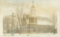
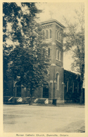 Roman Catholic Church Dunnville Ontario Brick building with central tower surrounded by trees
 -
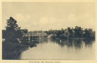 Byng Bridge near Dunnville Ontario Byng Bridge in background ; bridge leads from Dunnville proper to the area of Byng ; Grand River in foreground;
 -
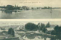 Lower Grand River Dunnville Ont [Ontario. Canal and Locks Dunnville Ont [Ontario] Title 1:Lower Grand River Dunnville Ont [Ontario ; Title 2: Canal and locks Dunnville Ont [Ontario]
 -
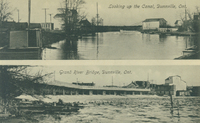 Looking up the canal Dunnville Ont [Ontario]. Grand River Bridge Dunnville Ont [Ontario] Title 1: view of the canal and bankside buildings ; Title 2: View of the Grand River Bridge
 -
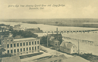 Bird's eye view showing Grand River and Long Bridge Dunnville Ont [Ontario] Grand River and shoreline in far distance ; one large building (left) and other smaller buildings (right)
 -
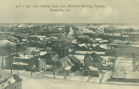 Bird's eye view looking east from Monarch Knitting factory Dunnville Ont [Ontario] View taken in winter shows mostly residential houses with some larger buildings ; snow is on the ground ;
 -
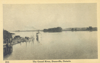 The Grand River Dunnville Ontario View of the Grand River with an island (centre background) and the shore in the distance (right) ; left there is a small dock and a small boat steaming toward the dock ;
 -
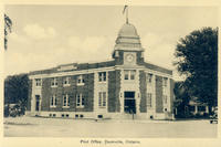 Post Office Dunnville Ontario Post office building with clock tower , flag on clock tower ; clock set to 1:20 pm and sign on left side of building reads "Dominion Public Building" sign above entrance "Dunnville", sign above door "Post Office" ; horse and wagon at left side partially hidden by building ;
 -
 Victoria Hotel Dunnville Ontario Cars are parked in front of the hotel ; there are awnings on each window and a sign for a restaurant in the hotel is at the far end of the building ;
 -
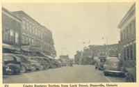 Centre Business Section From Lock Street Dunnville Ontario Business section of downtown Dunnville, many shops and stores line the streets ; cars are parked on all sides ;
 -
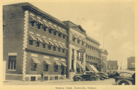
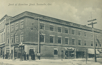 Bank of Hamilton Block Dunnville Ont [Ontario] The large downtown block fills the entire image ; a group of men are gathered outside the bank in the centre ; snow is on the ground and a sign "Skating tonight" is attached to a hydro pole to the right of the bank ;
 -
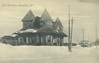 GTR [Grand Trunk Railway] Station Dunnville Ont [Ontario] The railway station is to the centre left of the image ; a boxcar can seen to the extreme left partially hidden by the station ; snow is on the ground ;
 -
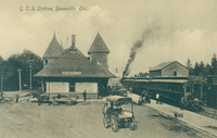 GTR [Grand Trunk Railway] Station Dunnville Ont [Ontario] The railway station is in the centre of the image ; a train and passengers are to the right of the station ; passengers are waiting on the platform ; a horse and cart and a horse and buggy are also in the image ;
 -
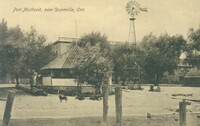 Port Maitland near Dunnville Ont [Ontario] Gazebo like structure in foreground, two men standing beside it ; windmill to the right of the gazebo ; large building in background mostly hidden by gazebo has sign reading C D Martin ...;
 -
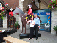 Dave and Teresa Quinn of Australia with Canadian Mountie cut out at Souvenir City Niagara Falls The statue of the Royal Canadian Mountie is located outside of Souvenir City on the Niagara Parkway
 -
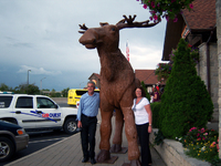 Dave and Teresa Quinn of Australia with large wooden moose at Souvenir City Niagara Falls Ontario The large wooden moose is located outside of Souvenir City on the Niagara Parkway which can be seen in the background
 -
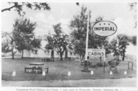 Evergreen Point Cabins and camp, 1 mile west of Dunnville Ontario Highway No 3 Cabins are shown in the background ; picnic tables ; Imperial dealer sign on pole ; sign advertising Heated Cabins ;