Browse Items
-
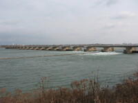 International Control Dam International Control Dam in the Upper Niagara River
 -
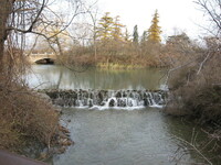 Dufferin Islands Small waterfall at Dufferin Islands with bridge in the background.
 -
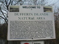 Dufferin Islands Welcome Sign Dufferin Islands welcome sign : "Welcome to Dufferin Islands Natural Area. Prior to 1903 the Dufferin Islands area was a natural and relatively unspoiled fast-flowing watercourse that was an off-shoot caused by the inclination of the underlying rock formation towards the Canaddian side of the river. By 1920 diversion of water for the generation of electricity and the construction of many smaller islands in the channel turned the watercourse into a sedate, slow-flowing series of pools and ponds. the disturbed soil became an excellent seed bed for many plants, insluding non-native invasive alien plant species (IAS) such as Tree-of-Heaven, Norway maple and Purple Loostrife. In 2007 the Niagara parks Commission developed a management plan for Dufferin Islands to preserve the natural resources that still exist on the site. IAS are being removed and appropriate native plant species planted to increase the habitat quality. Interpretive trails are being upgraded and many interior trails have been closed to allow for natural regeneration for improved wildlife habitat. For more information visit www.Niagaraparksnature.com and please, stay on the gravel trails."
 -
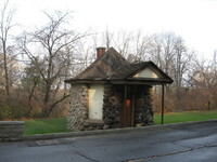 Small Building at Dufferin Islands Small octagonal building located at Dufferin Islands.
 -
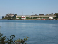
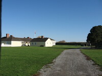
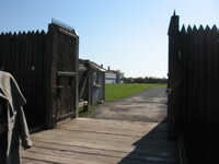 Front gates of Fort George, Niagara-on-the-Lake The open wooden front gates of Fort George, Niagara-on-the-Lake
 -
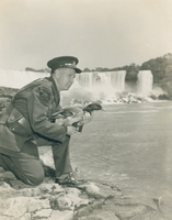
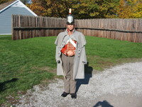 Employee at Fort George dressed in military uniform An employee at Fort George dressed in military uniform.
 -
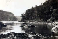
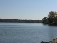 Lower Niagara River at its mouth in Niagara-on-the-Lake The lower Niagara River at its mouth in Niagara-on-the-Lake.
 -
 Fort Niagara, United States Looking across the lower Niagara River at Fort Niagara in the United States.
 -
 Fort Niagara, United States Looking across the lower Niagara River at Fort Niagara in the United States.
 -
 Fort Niagara, United States Looking across the lower Niagara River at Fort Niagara in the United States.
 -
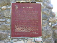 Fort George Plaque Plaque at Fort George: "Fort George. Constructed by Lieutenant Govenor Simcoe 1796-99, Fort George served as headquarters for Major-General Brock in 1812. In May 1813 it was bombarded and captured by the Americans who constructed fortifications of their own on the site. These in turn were retaken by the British in December 1813. In 1815 Fort George was described as 'tumbling into ruins' and ordered abandoned. The present works are a reconstruction done in 1937-40, and represent this fort as it was in 1799-1813. Only the magazine of the original fort remains."
 -
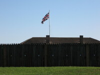 The Union Jack flag flying at Fort George, Niagara-on-the-Lake The Union Jack flying at Fort George, Niagara -on-the-Lake.
 -
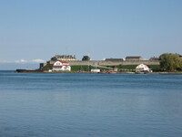
 Building and a cannon in Fort George, Niagara-on-the-Lake Stone road leading up to some buildings and a cannon in Fort George, Niagara-on-the-Lake
 -
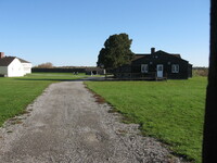 Buildings and a cannon in Fort George, Niagara-on-the-Lake Stone road leading up to some buildings and a cannon in Fort George, Niagara-on-the-Lake
 -
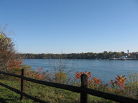 Fall colours along the Lower Niagara River at Niagara-on-the-Lake Fall colours on the trees along the lower Niagara River looking across to the American side.
 -
 Fall colours along the Lower Niagara River at Niagara-on-the-Lake Fall colours on the trees along the lower Niagara River looking across to the American side.
 -
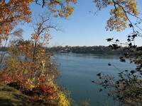
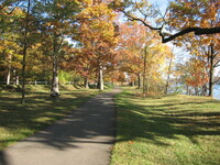 Fall colours along the Niagara River Recreational Trail in Niagara-on-the-Lake Fall colours on the trees along the Niagara River Recreational Trail with the Niagara River in the background.
 -
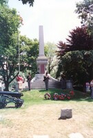 Ceremony at the Lundy's Lane Memorial in Drummond Hill Cemetery Part of the 2004 Snapshot of Niagara Project. Ceremony at the Lundy's Lane Monument found in Drummond Hill Cemetery commemorating the Battle of Lundy's Lane, unveiled July 25, 1895.
 -
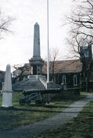 Lundy's Lane Monument in Drummond Hill Cemetery Part of the 2004 Snapshot of Niagara Project. Lundy's Lane Monument found in Drummond Hill Cemetery commemorating the Battle of Lundy's Lane, unveiled July 25, 1895. In the background is the Drummond Hill Presbyterian Church.
 -
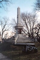 Lundy's Lane Monument in Drummond Hill Cemetery Part of the 2004 Snapshot of Niagara Project. Lundy's Lane Monument found in Drummond Hill Cemetery commemorating the Battle of Lundy's Lane, unveiled July 25, 1895.
 -
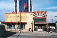 East Side Mario's Restaurant Part of the 2004 Snapshot of Niagara Project. East Side Mario's Restaurant on Ferry Street
 -
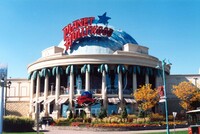 Planet Hollywood Restaurant Part of the 2004 Snapshot of Niagara Project. Planet Hollywood Restaurant on Bender Avenue
 -
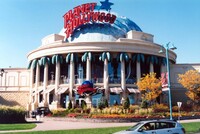 Planet Hollywood Restaurant Part of the 2004 Snapshot of Niagara Project. Planet Hollywood Restaurant on Bender Avenue.
 -
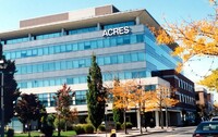 Acres Building Part of the 2004 Snapshot of Niagara Project. Acres Building on Queen Street
 -
 Bird Kingdom : the Niagara Falls Aviary Part of the 2004 Snapshot of Niagara Project. Bird Kingdom: the Niagara Falls Aviary on River Road, formerly the Old Niagara Falls Museum and Spirella Building.
 -
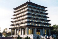 Buddhist Temple Part of the 2004 Snapshot of Niagara Project. Buddhist Temple on River Road
 -
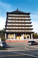 Buddist Temple Part of the 2004 Snapshot of Niagara Project. Buddhist Temple on River Road
 -
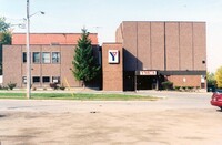
 YWCA of Niagara Falls Part of the 2004 Snapshot of Niagara Project. YWCA of Niagara Falls
 -
 Gales Gas Bar on Bridge Street Part of the 2004 Snapshot of Niagara Project. Gales Gas Bar on Bridge Street
 -
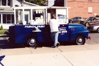
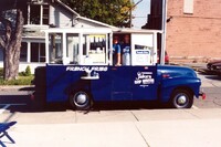
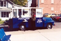 Jake's Chip Wagon on St. Clair Avenue Part of the 2004 Snapshot of Niagara Project. Jake's Chip Wagon on St. Clair Avenue
 -
 Jake's Chip Wagon on St. Clair Avenue Part of the 2004 Snapshot of Niagara Project. Jake's Chip Wagon on St. Clair Avenue
 -
 Jake's Chip Wagon on St. Clair Avenue Part of the 2004 Snapshot of Niagara Project. Jake's Chip Wagon on St. Clair Avenue
 -
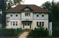
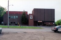
 The old YMCA building Part of the 2004 Snapshot of Niagara Project. The old YMCA building of Niagara Falls.
 -
 The old YMCA building Part of the 2004 Snapshot of Niagara Project. The old YMCA building of Niagara Falls.
 -
 YWCA of Niagara Falls Part of the 2004 Snapshot of Niagara Project. YWCA of Niagara Falls
 -
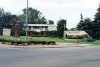 Sign for Downtown Niagara Falls Part of the 2004 Snapshot of Niagara Project. Sign for Downtown Niagara Falls at the corner of River Rd. and Queen St, with the Happiness Inn in the background.
 -
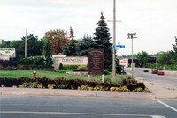 Sign for Downtown Niagara Falls Part of the 2004 Snapshot of Niagara Project. Sign for Downtown Niagara Falls at the corner of River Rd. and Queen St.
 -
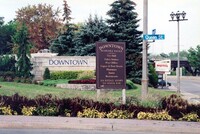 Sign for Downtown Niagara Falls Part of the 2004 Snapshot of Niagara Project. Sign for Downtown Niagara Falls at the corner of River Rd. and Queen St.
 -
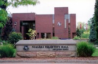
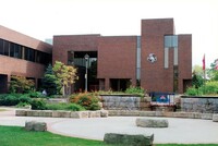 Niagara Falls City Hall Part of the 2004 Snapshot of Niagara Project. The front of Niagara Falls City Hall.
 -
 Niagara Falls City Hall Part of the 2004 Snapshot of Niagara Project. The front of Niagara Falls City Hall.
 -
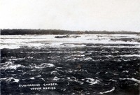 Submarine chaser "Sunbeam" stranded in the upper rapids of the Niagara River Submarine chaser "Sunbeam" stranded in the upper rapids of the Niagara River
 -
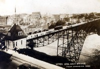 Upper Steel Arch Bridge The Upper Steel Arch bridge taken from the Canadian side with Niagara Fall, New York in the background
 -
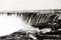 Brink of the Horseshoe Falls Brink of the Horseshoe Falls
 -
 Horseshoe Falls from Goat Island The Niagara Glen
 -
 Bridal Veil Falls and Cave of the Winds The Niagara Glen
 -
 Niagara Glen The Niagara Glen
 -
 Horseshoe Falls and Ontario Power House The Horseshoe Falls in the distance with the Ontario Power House to the right.
 -
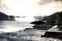
 American Falls and Horseshoe Falls The American Falls, the Horseshoe Falls and the lower Niagara River
 -
 Maid of the Mist under the Honeymoon Bridge Maid of the Mist boat under the Honeymoon bridge
 -
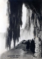 Horseshoe Falls in Winter Horseshoe Falls in the winter
 -
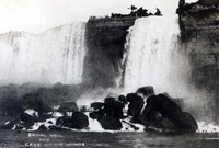
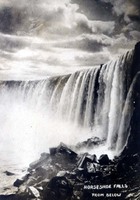 Horseshoe Falls from below Horseshoe Falls taken from below
 -
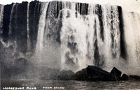 Horseshoe Falls from below Horseshoe Falls taken from below
 -
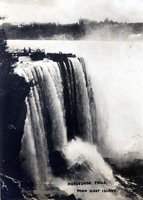
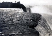 Brink of the American Falls Brink of the American Falls with the Horseshoe Falls and Goat Island in the background
 -
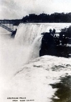 American Falls from Goat Island American Falls with the Honeymoon Bridge in the background taken from Goat Island
 -
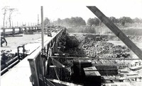
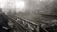
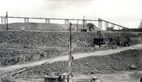
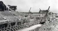
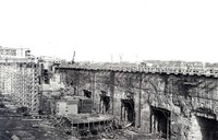
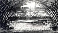
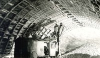
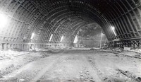
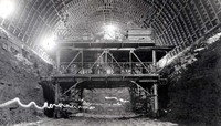
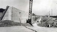
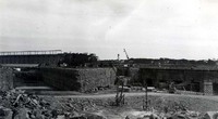
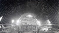
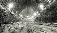
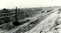
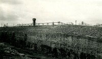
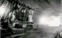
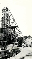
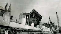
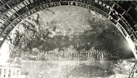
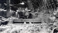
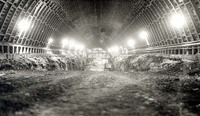
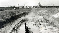
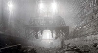
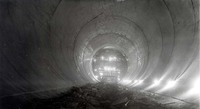
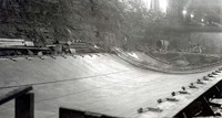
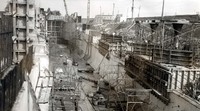
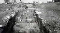
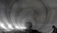
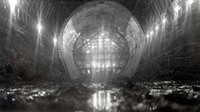
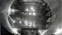
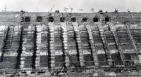 Construction of the Hydro Electric Power Tunnels Photographer unknown, obtained by Raymond Miron who worked in the tunnels in 1954.
 -
 Construction of the Hydro Electric Power Tunnels Photographer unknown, obtained by Raymond Miron who worked in the tunnels in 1954.
 -
 Construction of the Hydro Electric Power Tunnels Photographer unknown, obtained by Raymond Miron who worked in the tunnels in 1954.
 -
 Construction of the Hydro Electric Power Tunnels Photographer unknown, obtained by Raymond Miron who worked in the tunnels in 1954.
 -
 Construction of the Hydro Electric Power Tunnels Photographer unknown, obtained by Raymond Miron who worked in the tunnels in 1954.
 -
 Construction of the Hydro Electric Power Tunnels Photographer unknown, obtained by Raymond Miron who worked in the tunnels in 1954.
 -
 Construction of the Hydro Electric Power Tunnels Photographer unknown, obtained by Raymond Miron who worked in the tunnels in 1954.
 -
 Construction of the Hydro Electric Power Tunnels Photographer unknown, obtained by Raymond Miron who worked in the tunnels in 1954.
 -
 Construction of the Hydro Electric Power Tunnels Photographer unknown, obtained by Raymond Miron who worked in the tunnels in 1954.
 -
 Construction of the Hydro Electric Power Tunnels Photographer unknown, obtained by Raymond Miron who worked in the tunnels in 1954.
 -
 Construction of the Hydro Electric Power Tunnels Photographer unknown, obtained by Raymond Miron who worked in the tunnels in 1954.
 -
 Construction of the Hydro Electric Power Tunnels Photographer unknown, obtained by Raymond Miron who worked in the tunnels in 1954.
 -
 Construction of the Hydro Electric Power Tunnels Photographer unknown, obtained by Raymond Miron who worked in the tunnels in 1954.
 -
 Construction of the Hydro Electric Power Tunnels Photographer unknown, obtained by Raymond Miron who worked in the tunnels in 1954.
 -
 Construction of the Hydro Electric Power Tunnels Photographer unknown, obtained by Raymond Miron who worked in the tunnels in 1954.
 -
 Construction of the Hydro Electric Power Tunnels Photographer unknown, obtained by Raymond Miron who worked in the tunnels in 1954.
 -
 Construction of the Hydro Electric Power Tunnels Photographer unknown, obtained by Raymond Miron who worked in the tunnels in 1954.
 -
 Construction of the Hydro Electric Power Tunnels Photographer unknown, obtained by Raymond Miron who worked in the tunnels in 1954.
 -
 Construction of the Hydro Electric Power Tunnels Photographer unknown, obtained by Raymond Miron who worked in the tunnels in 1954.
 -
 Construction of the Hydro Electric Power Tunnels Photographer unknown, obtained by Raymond Miron who worked in the tunnels in 1954.
 -
 Construction of the Hydro Electric Power Tunnels Photographer unknown, obtained by Raymond Miron who worked in the tunnels in 1954.
 -
 Construction of the Hydro Electric Power Tunnels Photographer unknown, obtained by Raymond Miron who worked in the tunnels in 1954.
 -
 Construction of the Hydro Electric Power Tunnels Photographer unknown, obtained by Raymond Miron who worked in the tunnels in 1954.
 -
 Construction of the Hydro Electric Power Tunnels Photographer unknown, obtained by Raymond Miron who worked in the tunnels in 1954.
 -
 Construction of the Hydro Electric Power Tunnels Photographer unknown, obtained by Raymond Miron who worked in the tunnels in 1954.
 -
 Construction of the Hydro Electric Power Tunnels Photographer unknown, obtained by Raymond Miron who worked in the tunnels in 1954.
 -
 Construction of the Hydro Electric Power Tunnels Photographer unknown, obtained by Raymond Miron who worked in the tunnels in 1954.
 -
 Construction of the Hydro Electric Power Tunnels Photographer unknown, obtained by Raymond Miron who worked in the tunnels in 1954.
 -
 Construction of the Hydro Electric Power Tunnels Photographer unknown, obtained by Raymond Miron who worked in the tunnels in 1954.
 -
 Construction of the Hydro Electric Power Tunnels Photographer unknown, obtained by Raymond Miron who worked in the tunnels in 1954.
 -
 Construction of the Hydro Electric Power Tunnels Photographer unknown, obtained by Raymond Miron who worked in the tunnels in 1954.
 -
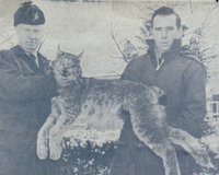 Conservation Officer A Roy Muma of the Ontario Department of Lands and Forests & Fish & Wildlife Niagara area and Reg Pineo with the first lynx known to have been shot in Niagara Property was located at Willoughby Drive Chippawa
 -
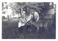
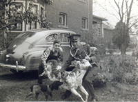 Conservation Officer A Roy Muma of the Ontario Department of Lands and Forests & Fish & Wildlife Niagara area with a rare black and white spotted deer L-R: Unknown, Officer Muma is holding the rare black and white deer brought in by a hunter ; a small beagle hunting dog is lower centre ; in background is a 1946 Dodge and the house located at 8200 Willoughby Drive ;
 -
 Conservation Officer A Roy Muma of the Ontario Department of Lands and Forests & Fish & Wildlife Niagara area showing a deer to his grandsons Keith, Allan and David L-R: Keith Muma, Allan Muma, David Muma, grandfather A Roy Muma ;
 -
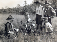
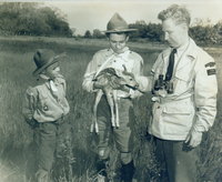 Conservation Officer A Roy Muma of the Ontario Department of Lands and Forests & Fish & Wildlife Niagara area showing a young deer to boy scouts Property was located at Willoughby Drive Chippawa
 -
 Conservation Officer A Roy Muma of the Ontario Department of Lands and Forests & Fish & Wildlife Niagara area showing a young deer to boy scouts Property was located at Willoughby Drive Chippawa
 -
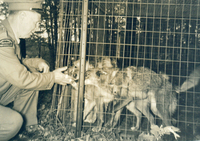 Conservation Officer A Roy Muma of the Ontario Department of Lands and Forests & Fish & Wildlife Niagara area with coyotes Officer Muma's property was located at Willoughby Drive Chippawa
 -
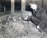 Conservation Officer A Roy Muma of the Ontario Department of Lands and Forests & Fish & Wildlife Niagara area with pheasant chicks Officer Muma's property was located at Willoughby Drive Chippawa
 -
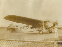 Ford Tri-Motor Miss Niagara of Skyview Airlines at Chippawa airfield "On July 4, 1928, " Sky View Lines, " inaugurated sightseeing flights, at night, over the " Niagara Falls. " The pilot, Major Leach, flying a " Ford Tri-Motor Airplane, " took off in the dark and in a few moments was over the " Falls "... the mighty " Horseshoe " clothed in rainbow shades... seemed only a few feet away. The " American Falls " were resplendent in white lights, while a white searchlight played on the big plane, which had the appearance of a mighty silver fish, while the moon looked on. Fifty people made the trip that night, among the earliest tourists to see the illuminated Falls, from the air. " Sky View Lines" had their landing field just south of " Chippawa, " on the " Niagara River Boulevard. F. H.Leslie Niagara Falls Review"
 -
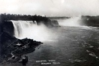
 General View of Niagara Falls with Seagram's Tower in foreground On back of postcard 'General view of Niagara Falls with Seagram's Tower in the foreground.
 -
 Maid of the Mist II On back of postcard 'Maid of the Mist II These steamers take their name from the legend of the Indian maid, who upon seeing her lover killed, leaped into a canoe and was carried over the Falls. To this day, according to the legend, the maid may be seen at the foot of the Falls as a misty figure with her arms reaching upward to her lover.
 -
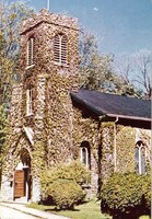 St. Mark's Anglican Church, ( Niagara-On-The-Lake ) On back of postcard 'St. mark's Anglican Church (1804-08) built in an Indian graveyard, where the trenches from the war of 1812 still remain. Architecturally significant are the double pulpits and the oldest chancel window in Upper Canada.
 -
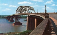 Peace Bridge Across Niagara River On back of postcard 'Peace Bridge across Niagara River Dedicated August 11, 1927, this bridge constitutes the largest single point of entry between U.S. and Canada. - Able to handle up to 33,000 cars per day it affords the tourist a spectacular view of the drama of the Niagara as it wends its way to the Falls.
 -
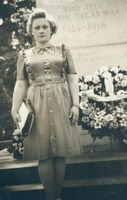 June Dunlop (nee Brander) on honeymoon in Niagara Falls June Dunlop is standing in front of the cenotaph located at the bottom of Clifton Hill
 -
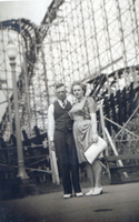 Webb and June (nee Brander) Dunlop on their honeymoon at Crystal Beach Ontario L-R: Webb Dunlop, June Dunlop; both are standing in front of the giant roller coaster located at the amusement park ;