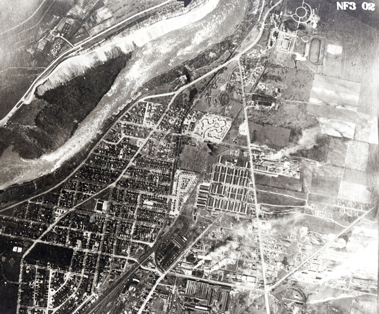
Aerial View of The Niagara Glen
item
- Title
- Aerial View of The Niagara Glen
- Description
- en-CA The Niagara Glen from the air taken in the late 1950's or early 1960's before the Robert Moses Power Plant drew water for electric power generation. Cripps Eddy, at the bottom left, still has water/ The narrowness of the gorge and the glen rapids are clearly shown. Devil's hole, the dark indentation just to the right of the Y in the road on the American side is visible, and the Devil's Hole rapids in the river to the right of the Devil's Hole. The Ontario Hydro access road, the white slash across the top right of the picture was built in early 1950 to provide access to the construction site for the Sir Adam Beck Generating Station Number 2.
- Identifier
- http://www.nflibrary.ca/nfplindex/show.asp?b=1&ref=oo&id=386921
- Creator
- New York State Power Authority
- Type
- Still Image
- Is Part Of
- Niagara Falls Public Library Digital Collections
- Extent
- 8" by 10"
- Medium
- Black & white photograph
- Provenance
- Schoellkopf Geological Museum
- Date
- c1960s
- Subject
- Aerial Views
- Niagara Glen
- Niagara Gorge
- Spatial Coverage
- Canada - Ontario - Niagara Falls
- Source
- Niagara Falls (Ont.) Public Library
- number
- D504946
- Format
- Black and white photograph
- Date Created
- 2013-04-17
- Date Modified
- 2013-04-17