Glacial Drift Dufferin Islands from "Our Romantic Niagara" by A.H. Tiplin
item
- Title
- Glacial Drift Dufferin Islands from "Our Romantic Niagara" by A.H. Tiplin
- Description
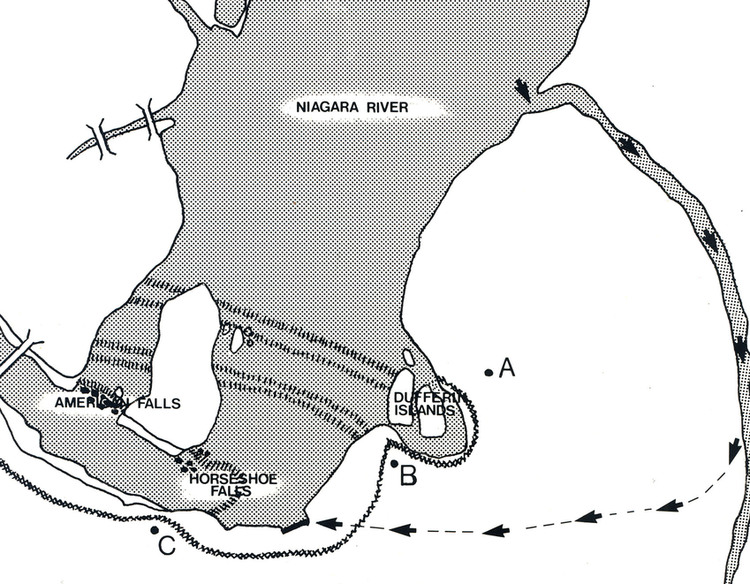
- en-CA Point "A" on the map marks the position of the first ridge of the ancient Falls-Chippawa valley, which diverted the water of the Niagara River toward the bank, to form the Dufferin islands embayment. The water of the embayment channel returns to the river along the edge of the lower cascade at "B". The curve on the map between points "B" and "C" was formed when the water level of the river was higher and the Falls was near Hubbard Point.
- Identifier
- http://www.nflibrary.ca/nfplindex/show.asp?b=1&ref=oo&id=385794
- Creator
- Astrid Akkerman from a sketch by A.H. Tiplin
- Type
- Still Image
- Is Part Of
- Niagara Falls Public Library Digital Collections
- Extent
- 6" by 7.5"
- Medium
- Black & white sketch
- Provenance
- Niagara Falls Heritage Foundation Collection
- Date
- 1988
- Subject
- Geology - Niagara Falls
- Dufferin Islands
- Spatial Coverage
- Canada - Ontario
- Source
- Niagara Falls (Ont.) Public Library
- number
- D504833
- D504833A
- Format
- Scan from book
- Scan from book
- Date Created
- 2013-03-14
- Date Modified
- 2013-03-14