Historical Images Item Set
Item set
Items
Browse Items
-
 Red Bull Crashed Ice Course, Niagara Falls, Canada The Red Bull Crashed Ice course at the base of the Skylon Tower.
 -
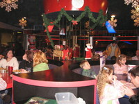
 Flying Saucer Restaurant, Niagara Falls, Canada Inside the Flying Saucer Restaurant which is decorated for Christmas. 6768 Lundy's Lane
 -
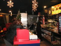
 Flying Saucer Restaurant, Niagara Falls, Canada Inside the Flying Saucer Restaurant space items are for sale. 6768 Lundy's Lane
 -
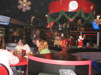
 Flying Saucer Restaurant, Niagara Falls, Canada Inside the Flying Saucer Restaurant which is decorated for Christmas. 6768 Lundy's Lane
 -
 Flying Saucer Restaurant, Niagara Falls, Canada Inside the Flying Saucer Restaurant which is decorated for Christmas. 6768 Lundy's Lane
 -
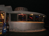 Flying Saucer Restaurant, Niagara Falls, Canada Flying Saucer Restaurant at night . 6768 Lundy's Lane
 -
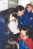
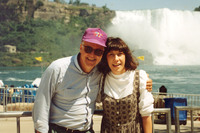
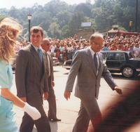 Duke and Duchess of York with George Bailey on their visit to Niagara Falls, July 18, 1987 Duke and Duchess of York with George Bailey on their visit to Niagara Falls on July 18, 1987
 -
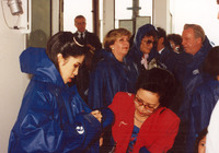
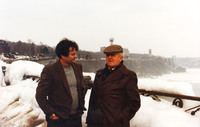
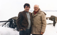
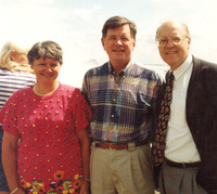 George Bailey with Eleanor and Clyde Wells, Premier of Newfoundland George Bailey, on the right with the Premier of Newfoundland, Clyde Wells and his wife, Eleanor.
 -
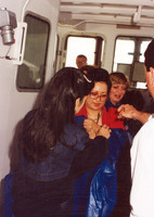
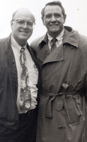 George Bailey and William Holden George Bailey with actor William Holden
 -
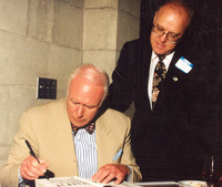 Pierre Berton and George Bailey Canadian author, Pierre Berton autographing a book, while George Bailey looks on.
 -
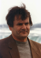
 Steve Landesberg with George Bailey George Bailey, on the left with Steve Landesberg, from the TV show Barney Miller
 -
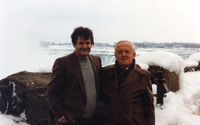
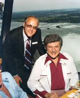 Liberace and George Bailey George Bailey, on the left with pianist Liberace in the Skylon Tower
 -
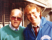
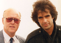
 Dan Aykroyd and George Bailey George Bailey, on the left with comedian Dan Aykroyd
 -
 Dorothy Hamill and George Bailey George Bailey, on right with U.S. figure skater Dorothy Hamill
 -
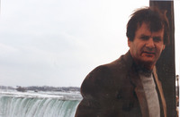
 George Bailey and Lily Tomlin George Bailey, on left with comedian Lily Tomlin in front of the American Falls on the Maid of the Mist boat ramp.
 -
 George Bailey and David Copperfield Goege Bailey, on left with magician David Copperield.
 -
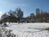
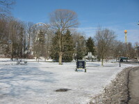 Queen Victoria Park in Winter Snow on the ground in Queen Victoria Park.
 -
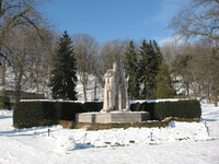 Statue of King George VI in Queen Victoria park in the winter Statue of King George VI surrounded by snow in Queen Victoria Park.
 -
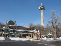 Edgewaters Restaurant and Skylon Tower in Winter, Niagara Falls, Canada Snow on the ground in front of Edgewaters Restaurant, with the Skylon Tower in the background.
 -
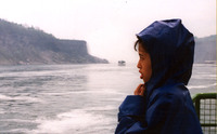
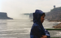
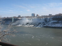
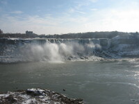
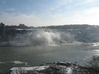
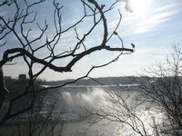
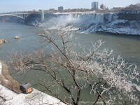 American Falls in Winter The American Falls in winter as seen from the Canadian side.
 -
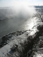
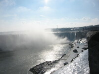
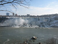
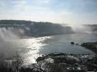
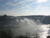
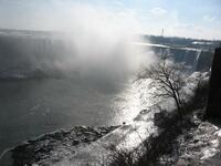 Horseshoe Falls in Winter The Horseshoe Falls and the lower Niagara River in winter.
 -
 Horseshoe Falls in Winter The Horseshoe Falls and the lower Niagara River in winter.
 -
 Horseshoe Falls in Winter The Horseshoe Falls and the lower Niagara River in winter.
 -
 American Falls in Winter The American Falls in winter as seen from the Canadian side.
 -
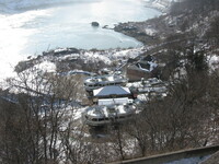
 Queen Victoria Park in Winter Snow on the ground in Queen Victoria Park near Murray Street in winter. The Fallsview casino and Hilton Hotels are visible in the background.
 -
 Horseshoe Falls in Winter The Horseshoe Falls and the lower Niagara River in winter.
 -
 American Falls in Winter The American Falls in winter as seen from the Canadian side.
 -
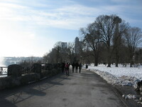 Tourists walking along the Niagara Parkway by the Horseshoe Falls in winter Tourists walking near the Horseshoe Falls along the Niagara parkway. The Skylon Tower and some hotels are visible in the background.
 -
 American Falls in Winter The American Falls in winter as seen from the Canadian side.
 -
 Horseshoe Falls in Winter The Horseshoe Falls and the lower Niagara River in winter.
 -
 American Falls in Winter The American Falls in winter as seen from the Canadian side.
 -
 Maid of the Mist Boats in Winter Drydock The Maid of the Mist Boats in their winter drydock on the Canadian side.
 -
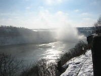
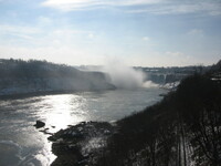
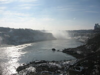
 American Falls and Horseshoe Falls in Winter The American Falls, the Horseshoe Falls and the lower Niagara River in winter.
 -
 Horseshoe Falls in Winter The Horseshoe Falls and the lower Niagara River in winter.
 -
 American Falls in Winter The American Falls in winter as seen from the Canadian side.
 -
 American Falls in Winter The American Falls in winter as seen from the Canadian side.
 -
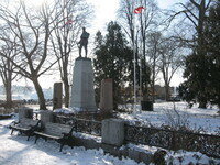 War Memorial on Clifton Hill, Niagara Falls, Canada The War memorial in winter on Clifton Hill. "To the glory of God and in grateful remembrance of the men of Niagara Falls who fell in the great wars 1914-1918, 1939-1945."
 -
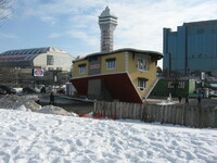 Upside Down House, Niagara Falls, Canada Snow on the ground near the Upside Down House on Oneida Lane, with the Casino Niagara Tower, the waterpark and the Sheraton on the Falls Hotel in the background.
 -
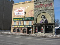 The Wild Mushroom Bar & Grill and Nightmares, Niagara Falls, Canada The Wild Mushroom Bar & Grill and Nightmares Museum on Victoria Avenue
 -
 The Hubbard Point Caves from "Our Romantic Niagara" by A.H. Tiplin Sunny's cave is 4.5 metres (15 feet) north of Bender's Cave. It was surveyed in June 1978 by Scott A. Ensminger and H.E. Krog. The entrance is 3 metres (10 feet) wide and 2.4 metres (8 feet) high. A passage to the west tapers to 0.9 metres (3 feet wide) and 15 centimetres (6 inches) highin 7.6 metres (25 feet).
 -
 Our Home on the Steps from "Our Romantic Niagara" by A.H. Tiplin This map shows Our Home on the Steps, that is plateaus or cuestas, with their fringes of worn rock: A- Allegheny Plateau on the horizon; E- Erie Plain with Onodaga Escarpment; H- Huron Plain with Niagara Escarpment; O- Ontario basin fringing with crystalline rocks to the north, the lowest and most weathered lowland.
 -
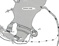
 The Whirlpool and the whirlpool rapids from "Our Romantic Niagara" by A.H. Tiplin This map shows the buried drainage pattern in the Niagara Peninsula as Dr. Spenser saw it as the result of his work in 1907. Present knowledge sees this drainage system in different light as reported by Flint and Loccam in Buried ancestral drainage between lake Erie and Ontario. "Over the past few decades, extensive data have become available and detailed bedrock surveys of areas within the Niagara Peninsula have been published. To date, however, no overall re-evaluation of the buried bedrock topography has been undertaken...Upstream from Niagara falls to lake Erie, the location of the St. David's drainage system remains unknown. However, more information collected, we assume it is unlikely that the channel carried a river which flowed in an opposite direction to the present Niagara River, but rather that it was a tributary of the Erigan for a relatively short geological time, before another channel was opened to drain Lake Erie. The St. David's channel may represent the only period, other than the present, when the great lakes emptied through the Niagara Peninsula.
 -
 Our Home on the Steps from "Our Romantic Niagara" by A.H. Tiplin The ancient ocean bottoms shown in position before millions of years of erosion could remove the strata to the level of "P" - the present surface of the Ontario Plain, with the deepest part filled by the lake. (Vertical scale much exaggerated). S- Salina rock; M- Medina rock; L -Lockport limestone
 -
 Five Stages of the Gorge from "Our Romantic Niagara" by A.H. Tiplin The Falls of Niagara had only a fraction of their usual flow during cutting of Old Erie Gorge, Stage II on the map. This period is much the longest in the history of the Falls. A- lake Algonquin; M- Mohawk Valley; T- Trent Valley; I- Lake Iroquois
 -
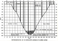 Our Home on the Steps from "Our Romantic Niagara" by A.H. Tiplin This sketch shows the results of Dr. J.W.W. Spencer's borings made in 1906 to ascertain the existence of a buried gorge at the dead end of the Whirlpool. In 1969 geologists George D. Hobson and Jaan Terasme drilled to bedrock to better define the buried channel and to bring up Pleistocene and fossil material for examination. Their results showed: clay 3.6 metres (6 feet); silt, sandy 8.5 metres (28 feet); clay 10 metres (33 feet); silt, sandy 14 metres (47 feet); sandy, gravelly till, 15.8 metres (52 Feet); silt, clayey 17.7 metres (58 feet); sand 21 metres (70 feet); clay 23.8 metres (78 feet); till with sand, gravel and cobbles 28.62 metres (94 feet); gravel and bulders 32.3 metres (106 feet); sand, some silt and clay 42 metres (138 feet); silty sand 44 metres (145 feet); clay with organic matter 45.4 metres (149 feet); sand with twigs and wood 46.6 metres (153 feet); sand, fine and medium 54 metres (178 feet); sand, fine to medium 55.7 metres (183 feet); gravel, cobbles, boulders with layers of glacial till, 84 metres (276 feet); bedrock, 86.8 metres (285 feet)
 -
 Rock Strata in the Gorge at the Whirlpool from "Our Romantic Niagara" by A.H. Tiplin The limits of the Whirlpool-St. Davids Buried Gorge are shown on this sketch. At "A" the water from Ontario Hydro's twin tunnels and canal had to be carried across the glacial debris of the buried gorge on concrete flumes. At "B" the escarpment rock is missing and is replaces by the many gullied hills of glacial drift. At "C" drillings revealed that the buried valley exists under the Lake Iroquois Beach Ridge.
 -
 Future of the Falls from "Our Romantic Niagara" by A.H. Tiplin In the 30.6 kilometres (19 miles) between the Lockport Limestone at Goat island and the Onandaga Limestone at Buffalo, the types of bedrock will cause the cataract to change a great deal. In the sketch, S= Silurian Age sea-beds composed of: I, Salina Limestone; II, Lockport Limestone; III, Clinton and Median shale and limestone formations; D, Devonian Age limestones which form the escarpment through Buffalo and which prevent Lake Erie from draining almost completely into the Niagara River; G, end of Goat island. The Falls will be much higher after cutting through the terraces of the ancient buried Falls-Chippawa valley; R, near here, at the southern end of Navy island, the Falls with either become a terraced cataract, like Letchworth Lower Falls, or will become a rapids because of the soft Salina shales which form most of the bed of the Upper Niagara River; P, Peace Bridge, where there now are rapids of a sort and the future site of another small cataract when the level of the Niagara River is gradually lowered by the falls cutting through the shales at "R".
 -
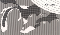
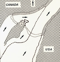
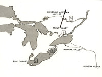 Former Outlets of the Great lakes from "Our Romantic Niagara" by A.H. Tiplin This sketch shows the former outlets of the Great lakes before the Falls cut back to the Glen. The arrow represents the slow retreat of the melting glacier, over a period of thousands of years. When the glacier was north of District "A" on the map, the easiest course for the melt waters was the Nipissing-Ottawa Outlet. When the surface of the land along this outlet rose after the weight of the glacier was removed from it, a new and lower passage for lake drainage opened up at "B", through Lake Simcoe and the Trent Valley System on to Lake Iroquois. The dotted area marked "E" shows the approximate size of the small Lake Erie whose waters formed stage II, the Old narrow or Erie Gorge. Modern lake Erie is shown at "C".
 -
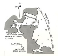 The Hubbard Point Caves from "Our Romantic Niagara" by A.H. Tiplin Indian cave or Redskin Cave is located 18 metres (60 feet) north of Sunny's cave. It was explored and its measurements were recorded by Scot A. Ensminger and B.R. Horncastle, in 1978. It is a much larger and interesting cave than bender's cave, but it is inaccessble, except by the use of rock climbing rquipment. The entrance is 15 metres (50 feet) wide, 2.5 to 3 metres (8 to 10 feet) high, and 2.1 to 6etres (7 to 20 feet) deep. Near the north side of the entrance, at the top slope, there is a 7.8 metres (26 feet) long crawlway to the west. This leads into a small room, 3 metres (10 feet) in diameter and 0.9 metres (3 feet) high. Two more crawlways lead from this room. One to the west is blocked by breakdowns in 1.5 metres (5 feet). The other, to the south, connects with a small room. A crawlway from this room, to the west, is blocked by dirt in a few feet. The cave contains small stalactites, romstone dams that are 5 centimetres (2 inches) high and flowstone. Near the south side of the entrance is another short crawlway which leads to a small room.
 -
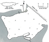 The Hubbard Point Caves from "Our Romantic Niagara" by A.H. Tiplin Bender's cave was surveyed by Scott A. Ensinger and H.E. Krog in January 1978. The numerals on this and the following sketches represent height inside the caves, in feet. The approaches to these caves are dangerous and caution is advised to those who would attempt to explore them without rock climbing equipment.
 -
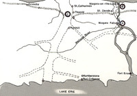
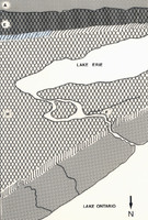
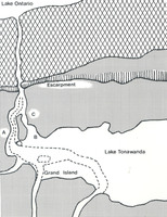 The Former lake Bed from "Our Romantic Niagara" by A.H. Tiplin This map was drawn from information contained in the United States Geological Survey of 1913. Ancient lake Tonawanda shows as merely an enlarged Niagara River which spilled over the 644 kilometres (400 miles) wscarpment at five main points - Holley, Medina, Gasport, Lockport and Lewiston in present day New York State. The Lewiston outlet prevailed to become the only outlet - the Niagara River
 -
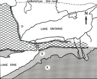
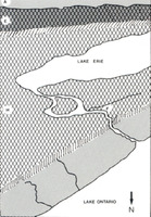 Our Escarpment from"Our Romantic Niagara" by A.H. Tiplin This map of cuesta topography shows the lowlands and their edges - our escarpment. O- Ontario plain; H- Huron Plain; E- Erie Plain; A- Allegheny Plain
 -
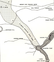
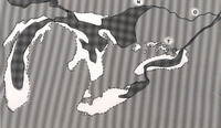
 Whirlpool-St. Davids Buried Gorge from "Our Romantic Niagara" by A.H. Tiplin This sketch of the Whilpool-St. Davids Gorge area is from the George D, Hobson and Jaan Terasmae study Pleistocene Geology of the Buried St. Davids Gorge, Niagara falls, Ontario; Geophysical and Palnological Studies, published 1969 by the Geological Survey of Canada. It shows the location of the buried St. Davids River channel as it wends its way through the lower fruitland plain to lake Ontario. The branch leading to the right is intersected by the present Niagara River just north of McFarland House on the lower Niagara Parkway.
 -
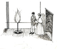 Natural gas from "Our Romantic Niagara" by A.H. Tiplin The Burning Spring from a guide book of the 1860's
 -
 Glacial Drift Dufferin Islands from "Our Romantic Niagara" by A.H. Tiplin Point "A" on the map marks the position of the first ridge of the ancient Falls-Chippawa valley, which diverted the water of the Niagara River toward the bank, to form the Dufferin islands embayment. The water of the embayment channel returns to the river along the edge of the lower cascade at "B". The curve on the map between points "B" and "C" was formed when the water level of the river was higher and the Falls was near Hubbard Point.
 -
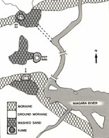 Niagara Falls Moraine from "Our Romantic Niagara" by A.H. Tiplin No.I Drummond Hill Kane, on Lundy's Lane Ridge which is on the Niagara Falls Moraine, shown by the checkered lines; No.II, Barre Moraine (St. Davids or Ravine Hill sand-pit), Indian Ossuary and edge of the escarpment; No. III, Fairview cemetery, a kame, at the western end of bridge Street in Niagara Falls.
 -
 Fall of Table Rock from "Our Romantic Niagara" by A.H. Tiplin On January 19, 1887, the Niagara Falls Gazette reported; " Wednesday night last a large section of rock on the Canadian side, close to the Horseshoe Fall, fell with a deafening crash and jarring the earth for some distance away. The exact position of the break, which was 150 feet (46 metres) long and 60 feet (18 metres) wide, was the point visitors will recall. It was close to the Horseshoe falls and protected by an iron railing. So little remains of the once famous Table Rock that it can hardly retain its name. It originally extended out so far that a person on the edge stood directly in front of a portion of the Horseshoe Falls. In 1818 a mass 160 feet (49 metres) by 30 or 40 feet (9 to 12 metres) in width fell. In the winter of 1828 and 1829 several large masses fell leaving the table-shaped ledge without support on the North and South sides. About mid-day on June 26th, 1850, this table fell with a terrible crash which startled inhabitants in the vicinity, the first impression being that an earthquake had occurred. It is said that a solitary stableman who was washing an omnibus on the rock escaped with his life, the vehicle, of which no traces were ever found, falling into the abyss. In 1862, several pieces of rock were blasted off as a prevention of accident." In 1897 other pieces broke off, leaving Table Rock as only a slight projection. Finally in 1935 what was left of the overhang was blasted off as a safety precaution. Table Rock remains today in name only.
 -
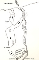
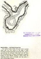 Whirlpool- Action of Water from "Our Romantic Niagara" by A.H. Tiplin The rush of water enters the pool and is carried down past the river outlet on the right. It then circulates counter-clockwise around the pool, and on approaching the entrance finds itself cut off from the incoming stream. Pressure (Hydrostatic pressure) builds up from behind, forcing it down under the incoming stream and it emerges near the outlet in dark rolling slugs of water.
 -
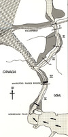
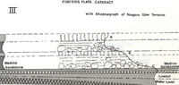 Wintergreen Flats from "Our Romantic Niagara" by A.H. Tiplin When the top falls had cut back to the northern end of the Glen- Cripps Eddy - it was overcome by the second or middle falls. Then a further lowering of the lake to modern levels, caused the third or lower falls to fall over the Medina Whirlpool Sandstone layer. Having a less resistant Queenston Shale to erode, it quickly eroded back along what is now the Foster's Flats level. It did not catch up with the other two falls, now combined, until almost at the Whirlpool.
 -
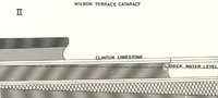 Wintergreen Flats from "Our Romantic Niagara" by A.H. Tiplin When the falls reached the point called Cripps Eddy, the level of Lake Iroquois fell 30.5 metres (100 feet) when a further tilting of the land at its outlet allowed the water to rush out via the St. Lawrence channel. A second falls then began at Lewiston-Queenston, and having less resistance rock to erode, soon eroded back to the Glen. Wilson Terrace was the crest of this falls.
 -
 Our Home on the Steps from "Our Romantic Niagara" by A.H. Tiplin Weathering has greatly eroded the ancient Palaeozoic ocean bottoms which used to fringe the northern crystalline rocks. On a south to North axis, reading left to right: P- Portage Escarpment; O- Onongada Escarpment; F- Falls of Niagara; N- Niagara Escarpment. Scale 1 centimetre equals 19 kilometres (one inch equals 30 miles).
 -
 Our Home on the Steps from "Our Romantic Niagara" by A.H. Tiplin This map of cuesta topography shows the lowlands and their eroded edges - our escarpment. O - Ontario Plain; H - Huron Plain; E - Erie Plain; A - Allegheny Plain
 -
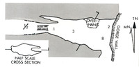
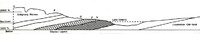
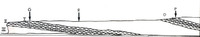
 Five Stages of the Gorge from "Our Romantic Niagara" by A.H. Tiplin The five stages of the gorge: I - Lesiston Branch Gorge (Lewiston Spillway Gorge); II - Old Narrow Gorge (Erie Gorge); III - Lower Great Gorge; IV - Whirlpool Rapids Gorge; V - Upper Great Gorge. The corresponding line alongside the river outline separated by white space denotes the high bank of the river during its various stages.
 -
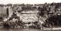 Site of the Schoellkopf Power Plant from "Our Romantic Niagara" by A.H. Tiplin Site of the Schoellkopf Power Plant over 30 years later, October 1987. More of the gorge wall has collapsed on the ruins of the power plant. Nature is trying to cover the remains with foliage.
 -
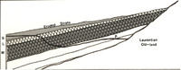
 Formation of the Sediment Beds from "Our Romantic Niagara" by A.H. Tiplin The light areas on the map represent dry land during the Silurian period of the Palaeozoic Era. The Palaeozoic Era was the geological era containing the oldest forms of highly organized life, including reptiles and seed-bearing plants, dating back from 500 million to 350 million years ago. The Silurian Period, dates back 430 to 390 million years. Niagara District sedimentary deposits, mostly sandstone, shale and marine limestone, were laid down in the Silurian Period. This is the third period in geological time during the Palaezoic Era.
 -
 Wintergreen Flats from "Our Romantic Niagara" by A.H. Tiplin By the time the falls had reached this point - Wintergreen Point - the outlet of lake Iroquois became blocked when the land thee rebounded after being relieved of the crushing weight of the glacier, so that comparatively little water could flow from Lake Iroquois to the ocean. The lake water backed up into the river, decreasing the height of the falls and reducing its erosive power.
 -
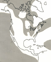
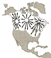 Ice Age Footprints from "Our Romantic Niagara" by A.H. Tiplin This map of ancient Arctic Canada was produced by the Canadian Government Department of Mines. The arrows point out main outflowings of thick ice from three main sources of glaciation occurring throughout a recent geological age at several different periods. Cause of such ice growth is not yet known.
 -
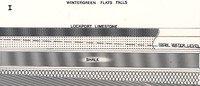
 Wintergreen Flats from "Our Romantic Niagara" by A.H. Tiplin This map shows the position of the divided falls when it reached the present Niagara Glen area. The heavy dotted line shows the gorge, formed by the three successive cataracts from three different layers of rock, through which the river flows today. The west falls on the right was to erode back faster than its branch falls, eventually cutting off the flow of water through this channel and drying off the eastern falls. This dried-off river bed is now the Wintergreen Flats picnic area. The American Falls will some day suffer the same fate as befell this western branch falls.
 -
 Five Stages of the Gorge from "Our Romantic Niagara" by A.H. Tiplin This map shows the Great lakes in the period just before the present level of flow began. Again the Falls of Niagara cut a narrow section of gorge - Stage IV Whirlpool Rapids. N- Nipissing Outlet; o - Ottawa River; T- Trent Valley
 -
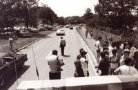
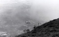
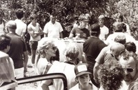
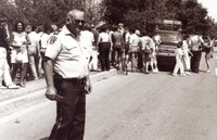 Crowd gathered for David Munday's trip over the Horseshoe Falls BARREL HORSESHOE FALLS HORSE SHOE NIAGARA
 -
 Crowd gathered for David Munday's trip over the Horseshoe Falls BARREL HORSESHOE FALLS HORSE SHOE NIAGARA
 -
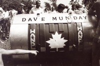
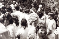 Crowd gathered around David Munday's Barrel BARREL HORSESHOE FALLS HORSE SHOE NIAGARA
 -
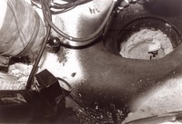 Internal view of the barrel Peter DeBernardi and Jeffrey Petkovich went over the Horseshoe falls in on Septemeber 28, 1989 The two Niagara Falls residents were the first duo to go over the falls in a reinforced barrel. They did so to draw attention to an anti-drugs campaign on September 28, 1989.
 -
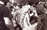
 Barrel used by Peter DeBernardi and Jeffrey Petkovich to go over the Horseshoe Falls on September 28, 1989 The two Niagara Falls residents were the first duo to go over the falls in a reinforced barrel. They did so to draw attention to an anti-drugs campaign on September 28, 1989.
 -
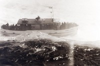
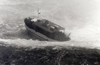 Maid of the Mist attempts to rescue David Munday in barrel below the Horseshoe Falls BARREL HORSESHOE FALLS HORSE SHOE NIAGARA
 -
 Maid of the Mist attempts to rescue David Munday in barrel below the Horseshoe Falls BARREL HORSESHOE FALLS HORSE SHOE NIAGARA
 -
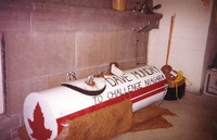
 Dave Munday in the barrel he went over the Horseshoe Falls with in the Lower Niagara River on October 5, 1985 BARREL HORSESHOE FALLS HORSE SHOE NIAGARA
 -
 Dave Munday in the barrel he went over the Horseshoe Falls with in the Lower Niagara River on October 5, 1985 BARREL HORSESHOE FALLS HORSE SHOE NIAGARA
 -
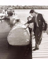
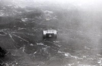
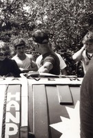
 Dave Munday's barrel impounded by police when he attempted to ride the lower rapids of the Niagara River. Niagara Parks Police impounded the 6.5' barrel Dave Munday attempted to use to ride the lower rapids of the Niagara River on September 26, 1987
 -
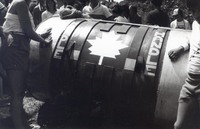
 Barrel used by John "David" Munday in a foiled attempt to go over the Horseshoe Falls 1985 BARREL HORSESHOE FALLS HORSE SHOE NIAGARA
 -
 Barrel used by John "David" Munday in a foiled attempt to go over the Horseshoe Falls 1985 BARREL HORSESHOE FALLS HORSE SHOE NIAGARA
 -
 Barrel used by John "David" Munday in a foiled attempt to go over the Horseshoe Falls 1985 BARREL HORSESHOE FALLS HORSE SHOE NIAGARA
 -
 Barrel used by John "David" Munday in a foiled attempt to go over the Horseshoe Falls 1985 BARREL HORSESHOE FALLS HORSE SHOE NIAGARA
 -
 Barrel used by John "David" Munday in a foiled attempt to go over the Horseshoe Falls 1985 BARREL HORSESHOE FALLS HORSE SHOE NIAGARA