Francis J. Petrie Collection
Item set
Items
Browse Items
-
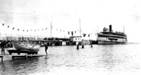
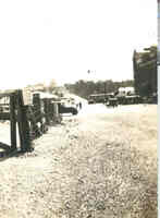
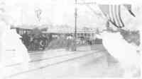
 The beach and pier at Crystal Beach Ontario, tour boat at the dock The boat at the the dock is probably the Canadiana which regularly brought tourists in from Buffalo
 -
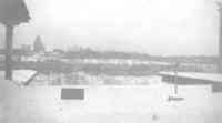
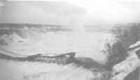
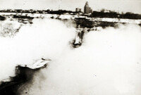
 Spectators on Luna Island in the Winter The American Falls appear to be completely frozen. Judging by the number of people that can be seen both above the gorge and below it is probable that this was taken in 1938, the year that the Falls View Bridge collapsed.
 -
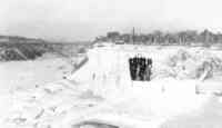
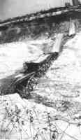
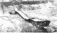
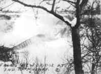
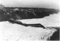
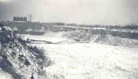
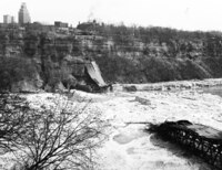
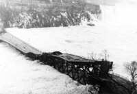
 Open end where the Falls View Bridge had been before its collapse. Looking over where the bridge used to be onto the American side of the gorge.
 -
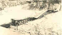
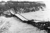
 View of Falls View Bridge before it collapsed. On January 27, 1938 an ice jam, exerting enormous pressure on the abutments of the Falls View Bridge, caused it to collapse onto the ice bridge below. It collapsed around 4:10 pm.
 -
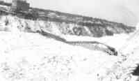
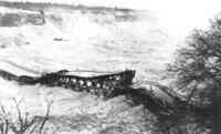
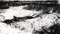
 Collapsed Falls View Bridge (34) On January 27, 1938 an ice jam, exerting enormous pressure on the abutments of the Falls View Bridge, caused it to collapse onto the ice bridge below. The Brock Hotel can be seen (top left) on the Canadian side.
 -
 Collapsed Falls View Bridge (33) On January 27, 1938 an ice jam, exerting enormous pressure on the abutments of the Falls View Bridge, caused it to collapse onto the ice bridge below. The American and Horseshoe Falls can be seen in the background.
 -
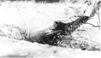
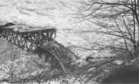
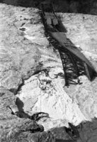
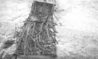 Wreckage of the Falls View Bridge after its collapse. On January 27, 1938 an ice jam, exerting enormous pressure on the abutments of the Falls View Bridge, caused it to collapse onto the ice bridge below. This is a close up of some of the debris.
 -
 Collapsed Falls View Bridge (32) On January 27, 1938 an ice jam, exerting enormous pressure on the abutments of the Falls View Bridge, caused it to collapse onto the ice bridge below. People can be seen near the base of the American Falls (top right).
 -
 Collapsed Falls View Bridge (31) On January 27, 1938 an ice jam, exerting enormous pressure on the abutments of the Falls View Bridge, caused it to collapse onto the ice bridge below. The American are in the background.
 -
 Collapsed Falls View Bridge (29) On January 27, 1938 an ice jam, exerting enormous pressure on the abutments of the Falls View Bridge, caused it to collapse onto the ice bridge below. The Brock Hotel is the tallest building pictured in the top left on the Canadian side of the gorge.
 -
 Collapsed Falls View Bridge (28) On January 27, 1938 an ice jam, exerting enormous pressure on the abutments of the Falls View Bridge, caused it to collapse onto the ice bridge below.
 -
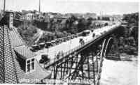
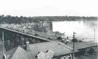
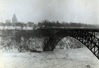
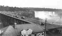 Canadian Customs House and traffic coming across the Falls View Bridge The American Falls are seen in the background. Traffic is coming from Niagara Falls, N.Y. to Niagara Falls, ON.
 -
 Collapsed Falls View Bridge (27) On January 27, 1938 an ice jam, exerting enormous pressure on the abutments of the Falls View Bridge, caused it to collapse onto the ice bridge below.
 -
 Collapsed Falls View Bridge (25) On January 27, 1938 an ice jam, exerting enormous pressure on the abutments of the Falls View Bridge, caused it to collapse onto the ice bridge below. Many people can be seen on the ice bridge in the upper right corner.
 -
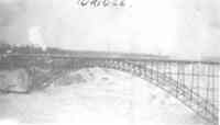
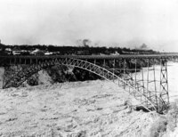
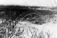
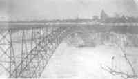 The Falls View Bridge looking towards Niagara Falls, N.Y. The Falls View Bridge served cross border traffic from 1898 until it collapsed in 1938.
 -
 Collapsed Falls View Bridge (24) On January 27, 1938 an ice jam, exerting enormous pressure on the abutments of the Falls View Bridge, caused it to collapse onto the ice bridge below. American Falls can be seen in background.
 -
 Collapsed Falls View Bridge (23) On January 27, 1938 an ice jam, exerting enormous pressure on the abutments of the Falls View Bridge, caused it to collapse onto the ice bridge below. American Falls can be seen in background. The back reads: Ready to go: Photo taken about 3 pm on Tues April 12, 1938 showing last remaining section of the fallen Falls View Bridge on its ice floe just prior to its departure downstream.
 -
 Collapsed Falls View Bridge (22) On January 27, 1938 the Falls View Bridge collapsed because of a major ice jam. Both Falls can be seen in the background. Small tear in the top left corner of the photograph.
 -
 Looking East down the Falls View Bridge The Falls View Bridge can be seen straight ahead. To the right is the La Fayette Hotel.
 -
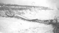
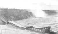
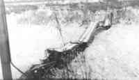
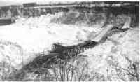
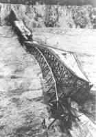
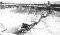
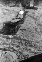
 Falls View Bridge immediately after it collapsed. On January 27, 1938 an ice jam, exerting enormous pressure on the abutments of the Falls View Bridge, caused it to collapse onto the ice bridge below.
 -
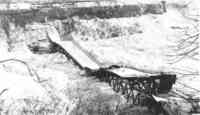
 Falls View Bridge as it begins to collapse. On January 27, 1938 an ice jam, exerting enormous pressure on the abutments of the Falls View Bridge, caused it to collapse onto the ice bridge below.
 -
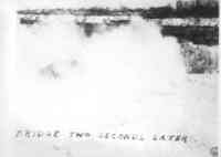 Falls View Bridge Two Seconds after the collapse. On January 27, 1938 an ice jam, exerting enormous pressure on the abutments of the Falls View Bridge, caused it to collapse onto the ice bridge below.
 -
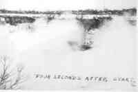 Falls View Bridge Four Seconds After it Collapsed. On January 27, 1938 an ice jam, exerting enormous pressure on the abutments of the Falls View Bridge, caused it to collapse onto the ice bridge below.
 -
 Collapsed Falls View Bridge (21) On January 27, 1938 an ice jam, exerting enormous pressure on the abutments of the Falls View Bridge, caused it to collapse onto the ice bridge below. Some tears in the original photo.
 -
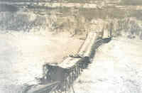
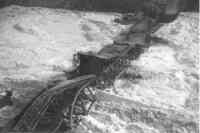
 Collapsed Falls View Bridge (19) On January 27, 1938 an ice jam, exerting enormous pressure on the abutments of the Falls View Bridge, caused it to collapse onto the ice bridge below. The ice has begun to break up and some of the bridge has sunk into the river.
 -
 People and Cars on the Falls View Bridge The photograph is damaged but shows men standing and cars on the Falls View Bridge.
 -
 Collapsed Falls View Bridge (17) On January 27, 1938 an ice jam, exerting enormous pressure on the abutments of the Falls View Bridge, caused it to collapse onto the ice bridge below. Some of the bridge has already sunk into the river. The American Falls can be seen in the background.
 -
 Collapsed Falls View Bridge (16) On January 27, 1938 an ice jam, exerting enormous pressure on the abutments of the Falls View Bridge, caused it to collapse onto the ice bridge below.
 -
 Collapsed Falls View Bridge (15) On January 27, 1938 an ice jam, exerting enormous pressure on the abutments of the Falls View Bridge, caused it to collapse onto the ice bridge below.
 -
 Collapsed Falls View Bridge (14) On January 27, 1938 an ice jam, exerting enormous pressure on the abutments of the Falls View Bridge, caused it to collapse onto the ice bridge below.
 -
 Collapsed Falls View Bridge (13) On January 27, 1938 an ice jam, exerting enormous pressure on the abutments of the Falls View Bridge, caused it to collapse onto the ice bridge below. The Falls can be seen in the background.
 -
 Collapsed Falls View Bridge (12) On January 27, 1938 an ice jam, exerting enormous pressure on the abutments of the Falls View Bridge, caused it to collapse onto the ice bridge below.
 -
 Collapsed Falls View Bridge (11) On January 27, 1938 an ice jam, exerting enormous pressure on the abutments of the Falls View Bridge, caused it to collapse onto the ice bridge below.
 -
 Collapsed Falls View Bridge (10) On January 27, 1938 an ice jam, exerting enormous pressure on the abutments of the Falls View Bridge, caused it to collapse onto the ice bridge below. People can be seen on the ice near the bridge, perhaps trying to get a souvenir.
 -
 Collapsed Falls View Bridge (9) On January 27, 1938 an ice jam, exerting enormous pressure on the abutments of the Falls View Bridge, caused it to collapse onto the ice bridge below. It collapsed around 4:10 pm.
 -
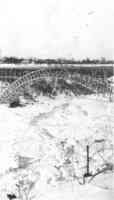
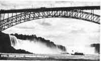 Upper Steel Arch Bridge - Niagara Falls, N.Y. The American and Horseshoe Falls can be seen in the background. Maid of the Mist can be seen below the bridge.
 -
 Falls View Bridge and Maid of the Mist vessels. Two Maid of the Mist ships can be seen near the dock. The incline railway can also be seen to the left, which would take people to the Maid of the Mist docks.
 -
 Collapsed Falls View Bridge (7) On January 27, 1938 an ice jam, exerting enormous pressure on the abutments of the Falls View Bridge, caused it to collapse onto the ice bridge below.
 -
 Collapsed Falls View Bridge (6) On January 27, 1938 an ice jam, exerting enormous pressure on the abutments of the Falls View Bridge, caused it to collapse onto the ice bridge below.
 -
 Upper Steel Arch Bridge - Niagara Falls Traffic can be seen coming across the bridge which connects Niagara Falls, ON and Niagara Falls, N.Y. The electric tram can also be seen coming across in the centre of the bridge.
 -
 Falls View Bridge before its collapse. Taken in January of 1938 before the collapse. The bridge was closed to traffic days before the collapse so there were no injuries.
 -
 Collapsed Falls View Bridge (2) On January 27, 1938 an ice jam, exerting enormous pressure on the abutments of the Falls View Bridge, caused it to collapse onto the ice bridge below.
 -
 Traffic on the Falls View Bridge Cars coming across the bridge to the Canadian side. The American Falls can be seen to the right.
 -
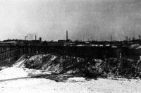
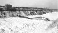
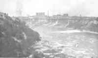
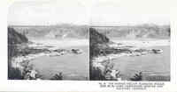 Upper Steel Arch Bridge with Factory District behind. Ice gorge below Niagara Falls, Feb. 23, 1906. Also Passenger bridge and factory district of Niagara Falls, N.Y.
 -
 Collapsed Falls View Bridge (1) On January 27, 1938 an ice jam, exerting enormous pressure on the abutments of the Falls View Bridge, caused it to collapse onto the ice bridge below. The incline railway can be seen to the left which used to extended down to the docks of The Maid of the Mist.
 -
 The Falls View Bridge The Falls View Bridge just prior to its collapse in 1938.
 -
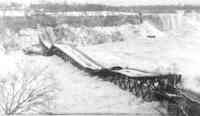
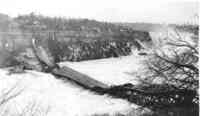
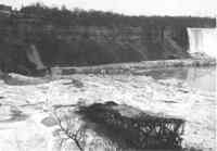
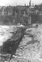
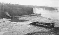
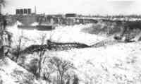
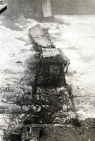
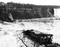 Remains of the fallen Falls View Bridge (2) As the ice bridge broke up after the collapse of the Falls View Bridge some pieces sank and others were carried downstream before sinking. The American Falls are in the background.
 -
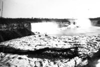
 Remains of the fallen Falls View Bridge As the ice bridge broke up after the collapse of the Falls View Bridge some pieces sank and others were carried downstream before sinking.
 -
 Wreckage of the Falls View Bridge with the American and Horseshoe Falls in the background. As the ice bridge broke up after the collapse of the Falls View Bridge some pieces sank and others were carried downstream before sinking.
 -
 Falls View Bridge Collapsing A massive ice jam in the Niagara River caused the Falls View Bridge to collapse January 27, 1938.
 -
 Collapsed Falls View Bridge - 1938 (6) A massive ice jam in the Niagara River caused the Falls View Bridge to collapse January 27, 1938.
 -
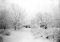
 Falls View Bridge in Winter The Falls View Bridge is also know as the Upper steel arch and Honeymoon Bridge.
 -
 The Falls View Bridge and Ice Bridge The Falls View Bridge is also know as the Upper Steel Arch and Honeymoon Bridge.
 -
 Collapsed Falls View Bridge - 1938 (5) A massive ice jam in the Niagara River caused the Falls View Bridge to collapse January 27, 1938.
 -
 Collapsed Falls View Bridge - 1938 (4) A massive ice jam in the Niagara River caused the Falls View Bridge to collapse January 27, 1938.
 -
 Collapsed Falls View Bridge - 1938 (3) A massive ice jam in the Niagara River caused the Falls View Bridge to collapse January 27, 1938.
 -
 Collapsed Falls View Bridge - 1938 (2) A massive ice jam in the Niagara River caused the Falls View Bridge to collapse January 27, 1938.
 -
 Collapsed Falls View Bridge - 1938 (1) A massive ice jam in the Niagara River caused the Falls View Bridge to collapse January 27, 1938.
 -
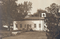 Laura Secord Homestead Queenston Ontario A single storey white frame house ; two large windows and one smaller window on each side of the front door ; a large flag pole flying the Canadian Maple Leaf flag is near the right end of the building ; property surrounded by large mature trees ;
 -
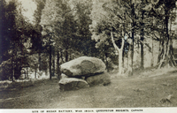 Site of Redan Battery War 1812-14 Queenston Heights Canada Monument commemorating the location of the redan battery used in the Battle of Queenston Heights centre ; monument consists of two very large boulders forming the base and a third boulder on top ; a plauq is attached to the top boulder ; very large mature trees surround the marker located on Queenston Heights ;
 -
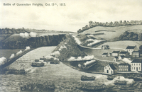 Battle of Queenston Heights Oct [October] 13th 1813 A black and white version of the famous painting of this War of 1812 battle ; American troops are shown crossing the Niagara River at the Village of Queenston in at least ten small row boats ; other troops line the American bank of the River ; small houses in the village of Queenston (bottom right) ; British troops are lined up on the Canadian side of the river and can be seen on the hill (called the Heights) in the background right ;
 -
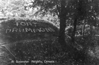 At Queenston Heights Canada Site of an earthwork fortification used during the War of 1812 ; site on a grassy knoll is marked by the words "Fort Drummond" laid out in what appears to be bricks ; many mature trees surround the site of the fortification ;
 -
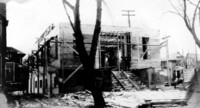
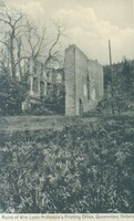 Ruins of Wm [William] Lyon Mackenzie's Printing Office Queenston Ontario Image has been taken from in front of the interior of the ruined house ; partial walls are on the right, left and back sides of the house ; a very large mature tree (left) has no leaves but there appears to be grass in front of the property and smaller trees (left):
 -
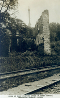 Ruins of first printing office in Upper Canada Queenston Heights Canada Image has been taken from in front of the interior of the ruined house ; partial walls are on the right and back sides of the house ; rest of the ruin is obscured by a very large mature tree (left : Brock's Monument is visible in the distance (centre) ; train tracks run alongside the ruin in the foreground ;
 -
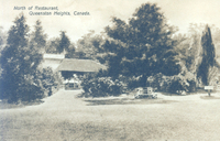 North of restaurant Queenston Heights Canada The restaurant is partially visible through the large mature surrounding it ; an overhead sign Restaurant is visible through the tress (centre) ; people can be seen underneath the porch (background) ; a formal rose bed is located in front of the property and a wooden bench is located next to the rose bed ; title in black print top left ;
 -
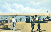
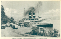 Steamer Cayuga of Canada Steamship Lines at Queenston Dock The steamship Cayuga at the Queenston Dock ; ship consists of two decks and has two striped funnels from which smoke is billoing ; the Niagara River is visible in the background ; buses and cars are parked awaiting passengers (left) ; a roof sign reading Toronto Boats" is over the open wooden building which serves as the station (centre);
 -
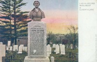 Laura Secord monument at Lundy's Lane The monument (centre) consists of a square column sitting atop a plain flat plinth and topped with a carved bust of Laura Secord ; an inscription runs down the centre of the column ; the location is Drummond Hill Cemetery ; various other headstones are in the background ; a white band runs down the right hand side of the card and the title is printed in black on this band ;
 -
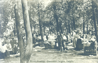 Picnic grounds Queenston Heights Canada A very large crowd of people are using the picnic area of the park ; tables are nestled in amongst very large mature trees ; this was a popular location for company picnics ;
 -
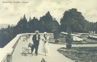 Queenston Heights Canada A man and a woman are walking along the pathway that wends it's way through the Queenston Heights park ; man is dressed in a suit and tie and is wearing a straw boater ; the woman is dressed in an ankle length dress and is wearing a cloche type hat ; wooden and metal benches are located around the viewing area ; two canons are situated in the background right ; two shrubs in planters line the pathway to the viewing area ;
 -
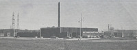
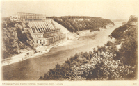 [Queenston] Chippawa Hydro Electric Station Queenston Ont [Ontario] Canada The power plant is on the left bank of the Niagara River as it passes through Queenston ; hydro plant buildings are located at the river's edge and also at the top of the gorge ; Niagara River flows through the centre of the image ;
 -
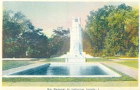 War Memorial St Catharines Canada A large white stone column with turrets on each corner ; a carved cartouche sits in the centre of the base ; three stone steps lead up a small slope to the monument ; a reflecting pool is in the front ; in the background either side are large mature leafy trees which are just beginning to change colour ; title in black print centre lower edge ;
 -
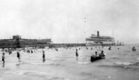
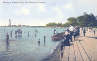 Bathing at Lakeside Park Port Dalhousie Canada Long shot of the sand bathing beach at Port Dalhousie ; many swimmers are in the water whilst others paddle ; four wooden rowing boats are pulled up onto the sand ; two women in bathing costumes in foreground ; other women in the image are dressed in floor length dresses and are wearing hats ; some carry parasols ; some people are sitting on a wooden boardwalk next to the water's edge; a large wooden structure possibly a life guard station is in the background right ; Port Dalhousie light house in background left ;
 -
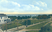 Lakeside Park Port Dalhousie Canada A distance view of the outer reaches of the park ;a two storey white house with a large porch and upper balcony (left) ; wooden poles carrying the overhead hydro for the electric train in foreground ; Port Dalhousie light house (centre right) ; Lake Ontario in background ;
 -
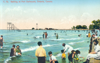
 Bathing beach Port Dalhousie Ont [Ontario] Long shot of the sand bathing beach at Port Dalhousie ; many swimmers are in the water whilst others paddle ; three wooden row boats are pulled up onto the sand ; two women in bathing costumes in foreground ; other women in the image are dressed in floor length dresses and are wearing hats ; some carry parasols ; wooden benches are along the water's edge ; Port Dalhousie light house in background centre right;
 -
 Bathing at Port Dalhousie Ontario Canada Long shot of the sand bathing beach at Port Dalhousie ; many swimmers are in the water whilst others paddle or sit on the edge of the dock ; a wooden structure possibly a diving tower (top left) ; Port dalhousie light house in background centre ;
 -
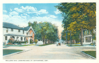 Welland Avenue looking east St Catharines Ont [Ontario] Residential street lined with large mature trees ; house on the left is a large two storey white residence with the addition of a red brick part on the right side ; a large porch covers the front of the house ; shrubs and trees in garden ; other houses on street obscured by trees ; a vehicle which is either a bicycle or a motor bike with a sidecar attached is being driven away from the camera ;
 -
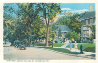 Yate Street corner College Street St Catharines Ont [Ontario] Partial view of two houses ; right a two story grey stone house with white trim windows, grey roof and a large chimney ; grass area and flower beds in front ; stone steps run through the front garden ; the house to the left is mostly obscured by the large mature trees surrounding the property ; two small children are standing on the boulevard in foreground (right) next to a fire hydrant ; a car is passing along the street (left) ;
 -
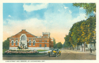 Lake Street and Armory St Catharines Ont [Ontario] Red brick and white stone building located at the corner of Welland Avenue and Lake Street ; flag pole attached to turret at the right side of the main entrance ; formal flower beds in front of the building ; a car is on the rigt side of the building ; tram streetcar tracks are visible right ; large mature trees line the sidewalk to the right ;
 -
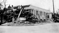
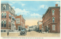 Queen Street looking south Post Office on the left St Catharines Ont [Ontario] Three storey red brick building in foreground ; entrance steps (bottom left) made of grey stone ; awnings on five windows at side of building ; steep dormer windows set into grey roof on upper level ; advertising sign on building next to Post Office reads Post Office Book Store ; The low building in background (right) is advertising an Insurance Company ? & Kernahan ? ; the red brick three storey building on the right is Bank of ? (printing is too blurred to read) ; an automobile is in the foreground centre and various other cars are parked along the right side of the street ;
 -
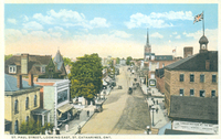 St Paul Street looking east St Catharines Ont [Ontario] Shops, businesses and houses line both sides of the street ; tram tracks run down the centre of the road ; railway station (bottom right) ; advertising sign on station reads Canadian Northern All The Way - Toronto- Winnipeg- Vancouver ; a Union Jack is flying from a turret atop the railway station ;
 -
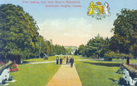 View looking east from Brock's Monument Queenston Heights Canada View of the tree lined pathway through the park ; ornate flower beds right and left ; military cannons from the War of 1812 behind each flower bed ; park visitors strolling along the path ; title in red print top centred ; Crest of the British Empire reading "On whose Dominions the sun never sets" top right corner ;
 -
 View of Queenston Heights Park looking east from Brock's Monument Canada View of the tree lined pathway through the park ; ornate flower beds right and left ; small children and families crossing the path ; a large group of soldiers walking away from the camera are in the distance right ; title in black print top left ; Crest of the British Empire reading "On whose Dominions the sun never sets" top right corner ;
 -
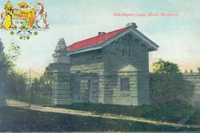 Gate keeper's lodge Brock Monument A small two storey grey stone building with a red brick roof ; stone wall to right of house ;gate post to the left of the house ; ornate wrought iron gates are closed ; a stone lion sits on top of the gate post ; a small tree grows in front of the property ; property ; a dirt road runs past the house in the foreground ; title in red print top right ; Crest of the British Empire reading "On whose Dominions the sun never sets" top left corner ;
 -
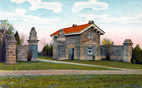 Niagara Falls Queenston Heights Ontario Gatekeeper's Lodge at Brock's monument A small two storey stone building with a red brick roof ; two stone walls either side of the house ; with posts at either end and in the middle ; middle posts serve as the gate posts for the gates which are wide open ; a stone lion is atop each of the gate posts ; a small wreath is on each of the smaller outside end posts ; small trees surround the property ; a dirt road runs past the house in the foreground ; title in black print bottom left ;
 -
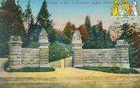
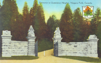 Entrance to Queenston Heights Park Niagara Falls Canada The wrought iron gates of the park are set into two stone walls with posts at either end and in the middle ; middle posts serve as the gate posts for the gates which are wide open ; a stone lion is atop each of the gate posts ; a small wreath is on each of the smaller outside end posts ; mature coniferous trees line the path in the background ; a crest reading Canada The Land Of The Maple Leaf top right corner ; title in black print is centred at the top ;
 -
 Entrance to park at Queenston Heights Ontario The wrought iron gates of the park are set into two stone walls with posts at either end and in the middle ; middle posts serve as the gate posts for the gates which are partially open ; a stone lion is atop each of the gate posts ; a small wreath is on each of the smaller outside end posts ; mature coniferous trees line the path in the background ; Crest of the British Empire reading On whose Dominion the sun never sets top right corner ; title in red print is centred at the top ;
 -
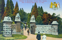 Entrance to Queenston Heights Park Canada site of famous battle October 13 1812 Two visitors are walking toward the turreted stone wall in which the wrought iron gates of the park are set ; two stone lions atop each of the gate posts ; other visitors can be seen in the distance walking along the path ; mature coniferous trees line the path ; Crest of the British Empire reading On whose Dominion the sun never sets top right corner ; title in red print is centred at the top ;
 -
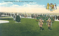 Looking towards Toronto Queenston Heights Canada Crowds line the edge of the park at Queenston Heights looking out at the river and the mouth of Lake Ontario ; two soldiers carrying rifles are in the foreground walking toward the camera ; two cannons from the war of 1812 in background centre and left ; Crest of the British Empire reading On whose Dominion the sun never sets top right corner ; title in black print is top left ;
 -
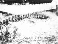
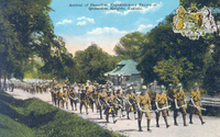 Arrival of Canadian Expeditionary Forces at Queenston Heights Canada Troops are marching up a tree lined road to Queenston Heights in the direction of Brock's monument, passing the railway station ; members of the band marching four abreast are leading the way; some wearing kilts and carrying bag pipes ; all dressed in khaki with bush ranger style hats ; other troops in far background ; train tracks of the Niagara Belt Line in centre background right ; Crest of the British Empire reading On whose Dominion the sun never sets top right corner ; title in black print is centre top ;
 -
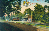 Niagara Belt Line car leaving station Queenston Heights Canada Station (centre) with crowds of people waiting outside for the streetcar ; some passengers shown walking away from the station (probably on way to the park) ; train tracks run right to left in the centre of the image ; large mature trees surround the area ; Dominion crest reading "On whose Dominions the sun never sets" top centre ;
 -
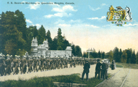 CE [Canadian Expeditionary Forces] recruits marching to Queenston Heights Canada Troops in khaki uniform are shown marching in two lines past the gated stone entrance to Queenston Heights park ; people are watching from the side of the railway tracks (right) ; Dominion crest reading "On whose Dominions the sun never sets" top right corner ;
 -
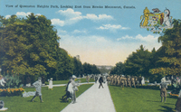
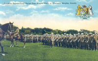 Canadian Expeditionary Forces From Niagara Camp, at Queenston Heights, Canada Troops in uniform and holding rifles are lined up on parade ; an officer on a horse is stationed in front of them ; another horse can be seen entering the picture left ; Dominion crest reading "On whose Dominions the sun never sets" top right corner
 -
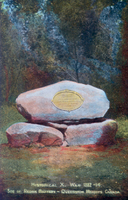 Historical X War 1812-1814 Site of Redan Battery Queenston Heights Canada Large stone monument resting on two smaller boulders ; brass plaque centre of top stone ;